You are here: Home > Network List > TA - USArray Transportable Network (new EarthScope stations) Stations List
> Station W52A Murphy, NC, USA > Earthquake Result Viewer
W52A Murphy, NC, USA - Earthquake Result Viewer
| Earthquake location: |
Northern Mid-Atlantic Ridge |
| Earthquake latitude/longitude: |
15.2/-45.2 |
| Earthquake time(UTC): |
2013/09/05 (248) 04:01:36 GMT |
| Earthquake Depth: |
10 km |
| Earthquake Magnitude: |
6.0 MWW, 5.9 MWB, 6.0 MWW, 6.0 MWC |
| Earthquake Catalog/Contributor: |
NEIC PDE/NEIC COMCAT |
|
| Network: |
TA USArray Transportable Network (new EarthScope stations) |
| Station: |
W52A Murphy, NC, USA |
| Lat/Lon: |
35.09 N/83.93 W |
| Elevation: |
519 m |
|
| Distance: |
39.9 deg |
| Az: |
306.978 deg |
| Baz: |
109.845 deg |
| Ray Param: |
0.07469842 |
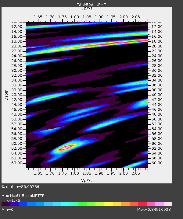
| Estimated Moho Depth: |
61.5 km |
| Estimated Crust Vp/Vs: |
1.76 |
| Assumed Crust Vp: |
6.35 km/s |
| Estimated Crust Vs: |
3.608 km/s |
| Estimated Crust Poisson's Ratio: |
0.26 |
|
| Radial Match: |
86.05736 % |
| Radial Bump: |
400 |
| Transverse Match: |
59.649662 % |
| Transverse Bump: |
400 |
| SOD ConfigId: |
626651 |
| Insert Time: |
2014-04-18 12:53:56.815 +0000 |
| GWidth: |
2.5 |
| Max Bumps: |
400 |
| Tol: |
0.001 |
|
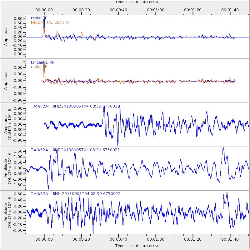
Signal To Noise
| Channel | StoN | STA | LTA |
| TA:W52A: :BHZ:20130905T04:08:39.675002Z | 6.156312 | 7.761687E-7 | 1.2607688E-7 |
| TA:W52A: :BHN:20130905T04:08:39.675002Z | 2.7260067 | 1.9903496E-7 | 7.301338E-8 |
| TA:W52A: :BHE:20130905T04:08:39.675002Z | 4.536472 | 4.6571662E-7 | 1.0266053E-7 |
| Arrivals |
| Ps | 7.9 SECOND |
| PpPs | 25 SECOND |
| PsPs/PpSs | 33 SECOND |


