You are here: Home > Network List > TA - USArray Transportable Network (new EarthScope stations) Stations List
> Station W53A Cullowhee, NC, USA > Earthquake Result Viewer
W53A Cullowhee, NC, USA - Earthquake Result Viewer

| Earthquake location: |
Northern Mid-Atlantic Ridge |
| Earthquake latitude/longitude: |
15.2/-45.2 |
| Earthquake time(UTC): |
2013/09/05 (248) 04:01:36 GMT |
| Earthquake Depth: |
10 km |
| Earthquake Magnitude: |
6.0 MWW, 5.9 MWB, 6.0 MWW, 6.0 MWC |
| Earthquake Catalog/Contributor: |
NEIC PDE/NEIC COMCAT |
|
| Network: |
TA USArray Transportable Network (new EarthScope stations) |
| Station: |
W53A Cullowhee, NC, USA |
| Lat/Lon: |
35.17 N/83.16 W |
| Elevation: |
1180 m |
|
| Distance: |
39.4 deg |
| Az: |
307.43 deg |
| Baz: |
110.631 deg |
| Ray Param: |
0.07502911 |
| Estimated Moho Depth: |
62.25 km |
| Estimated Crust Vp/Vs: |
1.68 |
| Assumed Crust Vp: |
6.35 km/s |
| Estimated Crust Vs: |
3.791 km/s |
| Estimated Crust Poisson's Ratio: |
0.22 |
|
| Radial Match: |
90.25316 % |
| Radial Bump: |
237 |
| Transverse Match: |
70.225914 % |
| Transverse Bump: |
400 |
| SOD ConfigId: |
626651 |
| Insert Time: |
2014-04-18 12:53:59.992 +0000 |
| GWidth: |
2.5 |
| Max Bumps: |
400 |
| Tol: |
0.001 |
|
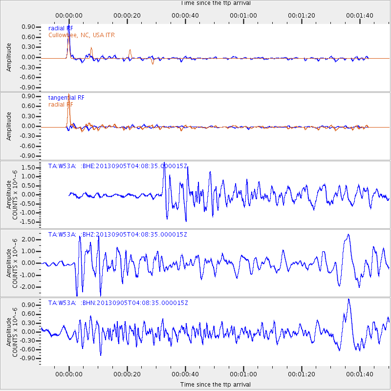
Signal To Noise
| Channel | StoN | STA | LTA |
| TA:W53A: :BHZ:20130905T04:08:35.000015Z | 8.827194 | 1.2476671E-6 | 1.4134358E-7 |
| TA:W53A: :BHN:20130905T04:08:35.000015Z | 2.264278 | 2.3149443E-7 | 1.02237635E-7 |
| TA:W53A: :BHE:20130905T04:08:35.000015Z | 10.249226 | 7.4144043E-7 | 7.234111E-8 |
| Arrivals |
| Ps | 7.1 SECOND |
| PpPs | 24 SECOND |
| PsPs/PpSs | 31 SECOND |


