You are here: Home > Network List > TA - USArray Transportable Network (new EarthScope stations) Stations List
> Station X43A Marvell, AR, USA > Earthquake Result Viewer
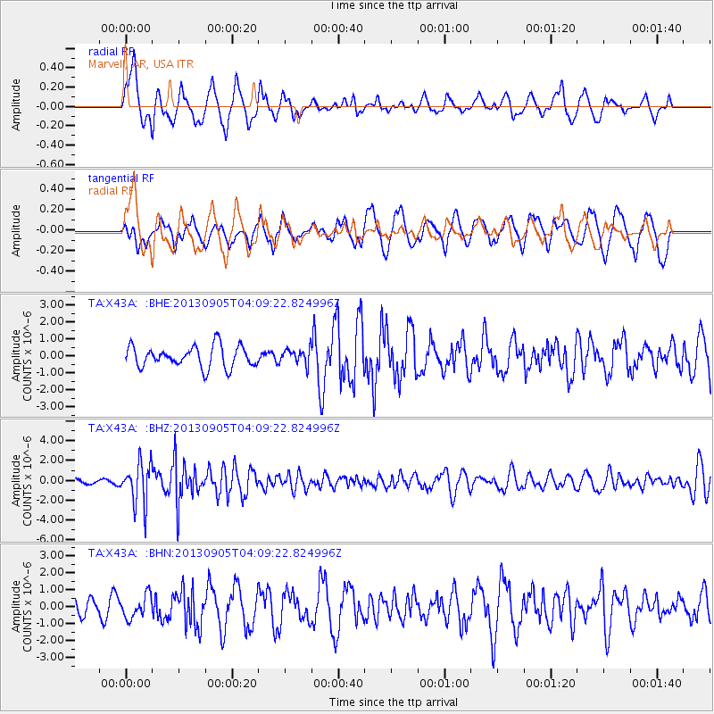
X43A Marvell, AR, USA - Earthquake Result Viewer
*The percent match for this event was below the threshold and hence no stack was calculated.
| Earthquake location: |
Northern Mid-Atlantic Ridge |
| Earthquake latitude/longitude: |
15.2/-45.2 |
| Earthquake time(UTC): |
2013/09/05 (248) 04:01:36 GMT |
| Earthquake Depth: |
10 km |
| Earthquake Magnitude: |
6.0 MWW, 5.9 MWB, 6.0 MWW, 6.0 MWC |
| Earthquake Catalog/Contributor: |
NEIC PDE/NEIC COMCAT |
|
| Network: |
TA USArray Transportable Network (new EarthScope stations) |
| Station: |
X43A Marvell, AR, USA |
| Lat/Lon: |
34.52 N/90.88 W |
| Elevation: |
53 m |
|
| Distance: |
45.2 deg |
| Az: |
303.742 deg |
| Baz: |
103.504 deg |
| Ray Param: |
$rayparam |
*The percent match for this event was below the threshold and hence was not used in the summary stack. |
|
| Radial Match: |
62.788403 % |
| Radial Bump: |
400 |
| Transverse Match: |
45.60386 % |
| Transverse Bump: |
400 |
| SOD ConfigId: |
626651 |
| Insert Time: |
2014-04-18 12:54:23.231 +0000 |
| GWidth: |
2.5 |
| Max Bumps: |
400 |
| Tol: |
0.001 |
|
Signal To Noise
| Channel | StoN | STA | LTA |
| TA:X43A: :BHZ:20130905T04:09:22.824996Z | 9.440388 | 2.1058286E-6 | 2.2306588E-7 |
| TA:X43A: :BHN:20130905T04:09:22.824996Z | 0.890995 | 6.864215E-7 | 7.703988E-7 |
| TA:X43A: :BHE:20130905T04:09:22.824996Z | 0.7214106 | 4.4880375E-7 | 6.221197E-7 |
| Arrivals |
| Ps | |
| PpPs | |
| PsPs/PpSs | |


