You are here: Home > Network List > TA - USArray Transportable Network (new EarthScope stations) Stations List
> Station Y12C Blythe, CA, USA > Earthquake Result Viewer
Y12C Blythe, CA, USA - Earthquake Result Viewer
| Earthquake location: |
Northern Mid-Atlantic Ridge |
| Earthquake latitude/longitude: |
15.2/-45.2 |
| Earthquake time(UTC): |
2013/09/05 (248) 04:01:36 GMT |
| Earthquake Depth: |
10 km |
| Earthquake Magnitude: |
6.0 MWW, 5.9 MWB, 6.0 MWW, 6.0 MWC |
| Earthquake Catalog/Contributor: |
NEIC PDE/NEIC COMCAT |
|
| Network: |
TA USArray Transportable Network (new EarthScope stations) |
| Station: |
Y12C Blythe, CA, USA |
| Lat/Lon: |
33.75 N/114.52 W |
| Elevation: |
196 m |
|
| Distance: |
64.6 deg |
| Az: |
300.4 deg |
| Baz: |
88.221 deg |
| Ray Param: |
0.0587965 |
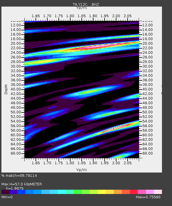
| Estimated Moho Depth: |
57.0 km |
| Estimated Crust Vp/Vs: |
1.99 |
| Assumed Crust Vp: |
6.155 km/s |
| Estimated Crust Vs: |
3.097 km/s |
| Estimated Crust Poisson's Ratio: |
0.33 |
|
| Radial Match: |
89.78114 % |
| Radial Bump: |
400 |
| Transverse Match: |
86.56092 % |
| Transverse Bump: |
400 |
| SOD ConfigId: |
626651 |
| Insert Time: |
2014-04-18 12:54:51.239 +0000 |
| GWidth: |
2.5 |
| Max Bumps: |
400 |
| Tol: |
0.001 |
|

Signal To Noise
| Channel | StoN | STA | LTA |
| TA:Y12C: :BHZ:20130905T04:11:42.868972Z | 4.3651433 | 7.31861E-7 | 1.6766026E-7 |
| TA:Y12C: :BHN:20130905T04:11:42.868972Z | 2.609678 | 1.1035584E-7 | 4.2287148E-8 |
| TA:Y12C: :BHE:20130905T04:11:42.868972Z | 2.110942 | 2.7832667E-7 | 1.3184952E-7 |
| Arrivals |
| Ps | 9.5 SECOND |
| PpPs | 27 SECOND |
| PsPs/PpSs | 36 SECOND |


