You are here: Home > Network List > TA - USArray Transportable Network (new EarthScope stations) Stations List
> Station Y49A New Hope, AL, USA > Earthquake Result Viewer
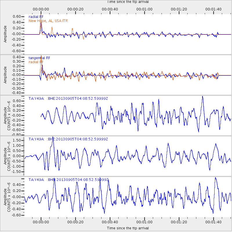
Y49A New Hope, AL, USA - Earthquake Result Viewer
*The percent match for this event was below the threshold and hence no stack was calculated.
| Earthquake location: |
Northern Mid-Atlantic Ridge |
| Earthquake latitude/longitude: |
15.2/-45.2 |
| Earthquake time(UTC): |
2013/09/05 (248) 04:01:36 GMT |
| Earthquake Depth: |
10 km |
| Earthquake Magnitude: |
6.0 MWW, 5.9 MWB, 6.0 MWW, 6.0 MWC |
| Earthquake Catalog/Contributor: |
NEIC PDE/NEIC COMCAT |
|
| Network: |
TA USArray Transportable Network (new EarthScope stations) |
| Station: |
Y49A New Hope, AL, USA |
| Lat/Lon: |
33.86 N/86.41 W |
| Elevation: |
362 m |
|
| Distance: |
41.5 deg |
| Az: |
304.205 deg |
| Baz: |
106.342 deg |
| Ray Param: |
$rayparam |
*The percent match for this event was below the threshold and hence was not used in the summary stack. |
|
| Radial Match: |
74.59121 % |
| Radial Bump: |
400 |
| Transverse Match: |
64.30723 % |
| Transverse Bump: |
400 |
| SOD ConfigId: |
626651 |
| Insert Time: |
2014-04-18 12:54:55.997 +0000 |
| GWidth: |
2.5 |
| Max Bumps: |
400 |
| Tol: |
0.001 |
|
Signal To Noise
| Channel | StoN | STA | LTA |
| TA:Y49A: :BHZ:20130905T04:08:52.59999Z | 3.597143 | 5.9984836E-7 | 1.6675689E-7 |
| TA:Y49A: :BHN:20130905T04:08:52.59999Z | 1.827207 | 1.5653929E-7 | 8.567135E-8 |
| TA:Y49A: :BHE:20130905T04:08:52.59999Z | 1.3633019 | 2.5513017E-7 | 1.8714135E-7 |
| Arrivals |
| Ps | |
| PpPs | |
| PsPs/PpSs | |


