You are here: Home > Network List > TA - USArray Transportable Network (new EarthScope stations) Stations List
> Station Y54A Tignall, GA, USA > Earthquake Result Viewer
Y54A Tignall, GA, USA - Earthquake Result Viewer
| Earthquake location: |
Northern Mid-Atlantic Ridge |
| Earthquake latitude/longitude: |
15.2/-45.2 |
| Earthquake time(UTC): |
2013/09/05 (248) 04:01:36 GMT |
| Earthquake Depth: |
10 km |
| Earthquake Magnitude: |
6.0 MWW, 5.9 MWB, 6.0 MWW, 6.0 MWC |
| Earthquake Catalog/Contributor: |
NEIC PDE/NEIC COMCAT |
|
| Network: |
TA USArray Transportable Network (new EarthScope stations) |
| Station: |
Y54A Tignall, GA, USA |
| Lat/Lon: |
33.86 N/82.69 W |
| Elevation: |
176 m |
|
| Distance: |
38.5 deg |
| Az: |
305.696 deg |
| Baz: |
109.55 deg |
| Ray Param: |
0.07550072 |
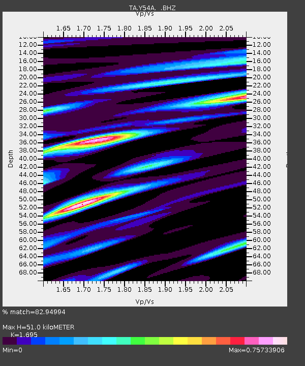
| Estimated Moho Depth: |
51.0 km |
| Estimated Crust Vp/Vs: |
1.70 |
| Assumed Crust Vp: |
6.565 km/s |
| Estimated Crust Vs: |
3.873 km/s |
| Estimated Crust Poisson's Ratio: |
0.23 |
|
| Radial Match: |
82.94994 % |
| Radial Bump: |
296 |
| Transverse Match: |
49.944736 % |
| Transverse Bump: |
400 |
| SOD ConfigId: |
626651 |
| Insert Time: |
2014-04-18 12:55:04.969 +0000 |
| GWidth: |
2.5 |
| Max Bumps: |
400 |
| Tol: |
0.001 |
|
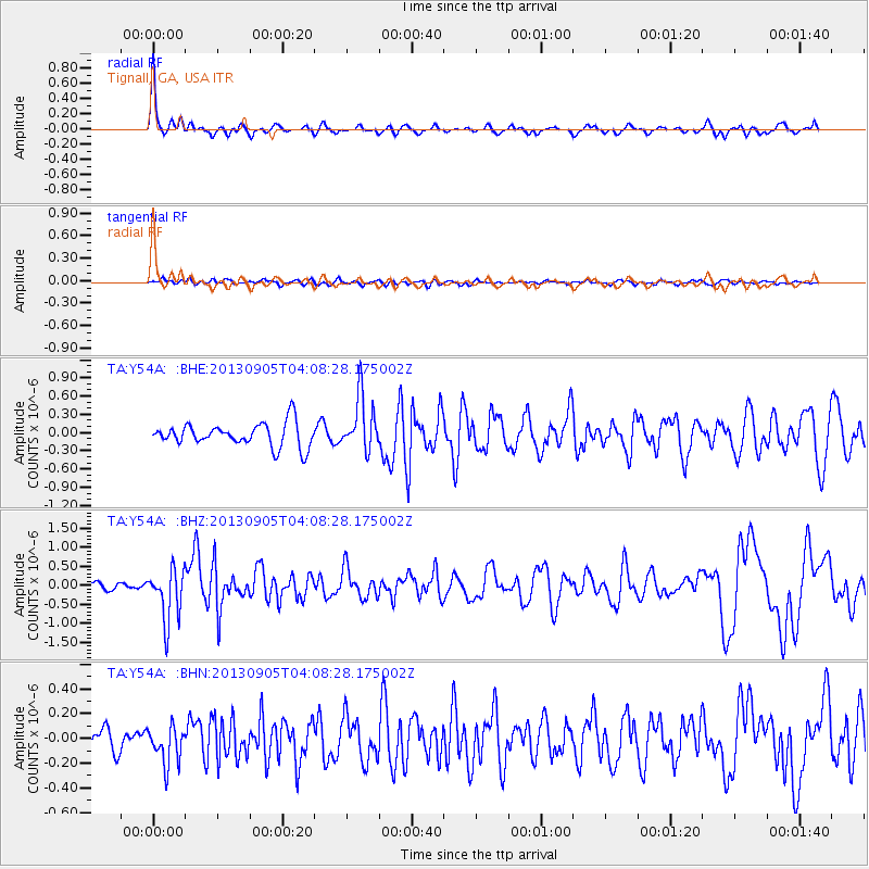
Signal To Noise
| Channel | StoN | STA | LTA |
| TA:Y54A: :BHZ:20130905T04:08:28.175002Z | 7.35578 | 6.887556E-7 | 9.363461E-8 |
| TA:Y54A: :BHN:20130905T04:08:28.175002Z | 1.77897 | 1.5324113E-7 | 8.614037E-8 |
| TA:Y54A: :BHE:20130905T04:08:28.175002Z | 2.2712607 | 4.390103E-7 | 1.9328925E-7 |
| Arrivals |
| Ps | 5.8 SECOND |
| PpPs | 19 SECOND |
| PsPs/PpSs | 25 SECOND |


