You are here: Home > Network List > TA - USArray Transportable Network (new EarthScope stations) Stations List
> Station Y56A Pelion, SC, USA > Earthquake Result Viewer
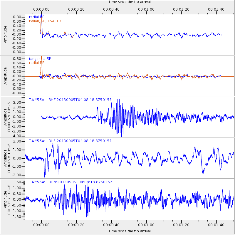
Y56A Pelion, SC, USA - Earthquake Result Viewer
*The percent match for this event was below the threshold and hence no stack was calculated.
| Earthquake location: |
Northern Mid-Atlantic Ridge |
| Earthquake latitude/longitude: |
15.2/-45.2 |
| Earthquake time(UTC): |
2013/09/05 (248) 04:01:36 GMT |
| Earthquake Depth: |
10 km |
| Earthquake Magnitude: |
6.0 MWW, 5.9 MWB, 6.0 MWW, 6.0 MWC |
| Earthquake Catalog/Contributor: |
NEIC PDE/NEIC COMCAT |
|
| Network: |
TA USArray Transportable Network (new EarthScope stations) |
| Station: |
Y56A Pelion, SC, USA |
| Lat/Lon: |
33.79 N/81.30 W |
| Elevation: |
154 m |
|
| Distance: |
37.4 deg |
| Az: |
306.234 deg |
| Baz: |
110.74 deg |
| Ray Param: |
$rayparam |
*The percent match for this event was below the threshold and hence was not used in the summary stack. |
|
| Radial Match: |
73.24877 % |
| Radial Bump: |
400 |
| Transverse Match: |
63.092087 % |
| Transverse Bump: |
400 |
| SOD ConfigId: |
626651 |
| Insert Time: |
2014-04-18 12:55:10.607 +0000 |
| GWidth: |
2.5 |
| Max Bumps: |
400 |
| Tol: |
0.001 |
|
Signal To Noise
| Channel | StoN | STA | LTA |
| TA:Y56A: :BHZ:20130905T04:08:18.875015Z | 4.899184 | 8.993315E-7 | 1.8356761E-7 |
| TA:Y56A: :BHN:20130905T04:08:18.875015Z | 1.864982 | 2.7908578E-7 | 1.4964529E-7 |
| TA:Y56A: :BHE:20130905T04:08:18.875015Z | 3.932132 | 7.6388847E-7 | 1.9426825E-7 |
| Arrivals |
| Ps | |
| PpPs | |
| PsPs/PpSs | |


