You are here: Home > Network List > TA - USArray Transportable Network (new EarthScope stations) Stations List
> Station Z54A Sparta, GA, USA > Earthquake Result Viewer
Z54A Sparta, GA, USA - Earthquake Result Viewer

| Earthquake location: |
Northern Mid-Atlantic Ridge |
| Earthquake latitude/longitude: |
15.2/-45.2 |
| Earthquake time(UTC): |
2013/09/05 (248) 04:01:36 GMT |
| Earthquake Depth: |
10 km |
| Earthquake Magnitude: |
6.0 MWW, 5.9 MWB, 6.0 MWW, 6.0 MWC |
| Earthquake Catalog/Contributor: |
NEIC PDE/NEIC COMCAT |
|
| Network: |
TA USArray Transportable Network (new EarthScope stations) |
| Station: |
Z54A Sparta, GA, USA |
| Lat/Lon: |
33.24 N/82.84 W |
| Elevation: |
134 m |
|
| Distance: |
38.5 deg |
| Az: |
304.681 deg |
| Baz: |
108.671 deg |
| Ray Param: |
0.07554872 |
| Estimated Moho Depth: |
26.0 km |
| Estimated Crust Vp/Vs: |
2.01 |
| Assumed Crust Vp: |
6.565 km/s |
| Estimated Crust Vs: |
3.266 km/s |
| Estimated Crust Poisson's Ratio: |
0.34 |
|
| Radial Match: |
84.46074 % |
| Radial Bump: |
285 |
| Transverse Match: |
59.93573 % |
| Transverse Bump: |
400 |
| SOD ConfigId: |
626651 |
| Insert Time: |
2014-04-18 12:55:33.601 +0000 |
| GWidth: |
2.5 |
| Max Bumps: |
400 |
| Tol: |
0.001 |
|
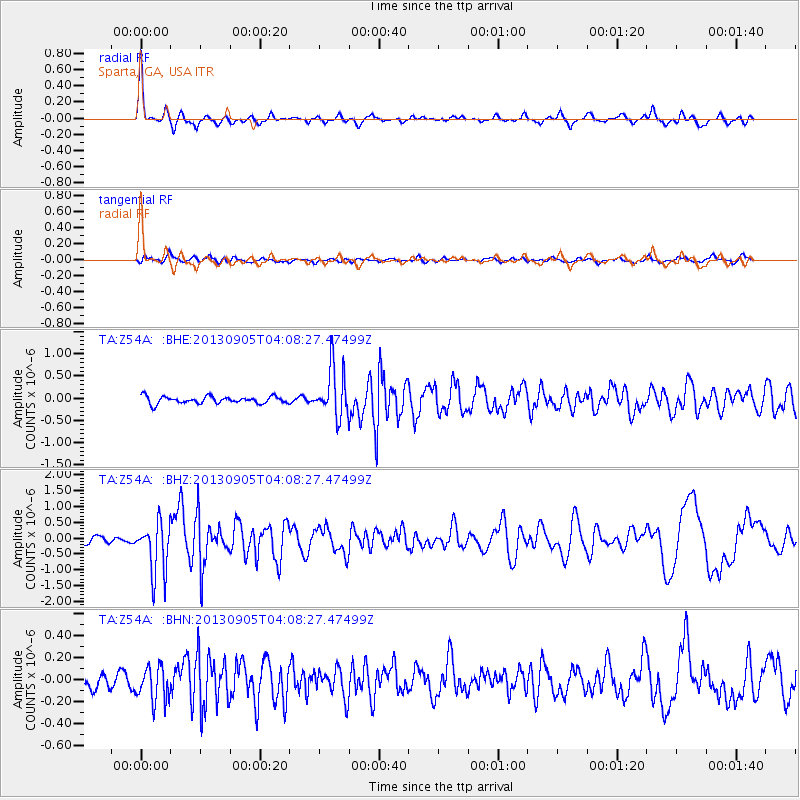
Signal To Noise
| Channel | StoN | STA | LTA |
| TA:Z54A: :BHZ:20130905T04:08:27.47499Z | 5.811055 | 8.374636E-7 | 1.4411559E-7 |
| TA:Z54A: :BHN:20130905T04:08:27.47499Z | 1.0388777 | 1.6028035E-7 | 1.5428222E-7 |
| TA:Z54A: :BHE:20130905T04:08:27.47499Z | 6.82953 | 5.4580636E-7 | 7.9918586E-8 |
| Arrivals |
| Ps | 4.3 SECOND |
| PpPs | 11 SECOND |
| PsPs/PpSs | 15 SECOND |


