You are here: Home > Network List > US - United States National Seismic Network Stations List
> Station AMTX Amarillo, Texas, USA > Earthquake Result Viewer
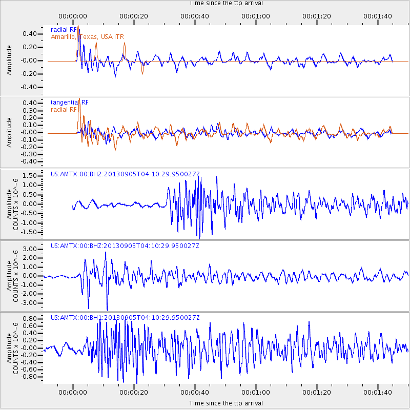
AMTX Amarillo, Texas, USA - Earthquake Result Viewer
*The percent match for this event was below the threshold and hence no stack was calculated.
| Earthquake location: |
Northern Mid-Atlantic Ridge |
| Earthquake latitude/longitude: |
15.2/-45.2 |
| Earthquake time(UTC): |
2013/09/05 (248) 04:01:36 GMT |
| Earthquake Depth: |
10 km |
| Earthquake Magnitude: |
6.0 MWW, 5.9 MWB, 6.0 MWW, 6.0 MWC |
| Earthquake Catalog/Contributor: |
NEIC PDE/NEIC COMCAT |
|
| Network: |
US United States National Seismic Network |
| Station: |
AMTX Amarillo, Texas, USA |
| Lat/Lon: |
34.53 N/101.41 W |
| Elevation: |
1010 m |
|
| Distance: |
53.8 deg |
| Az: |
301.796 deg |
| Baz: |
96.287 deg |
| Ray Param: |
$rayparam |
*The percent match for this event was below the threshold and hence was not used in the summary stack. |
|
| Radial Match: |
77.87935 % |
| Radial Bump: |
400 |
| Transverse Match: |
79.93605 % |
| Transverse Bump: |
400 |
| SOD ConfigId: |
626651 |
| Insert Time: |
2014-04-18 12:56:07.571 +0000 |
| GWidth: |
2.5 |
| Max Bumps: |
400 |
| Tol: |
0.001 |
|
Signal To Noise
| Channel | StoN | STA | LTA |
| US:AMTX:00:BHZ:20130905T04:10:29.950027Z | 6.426886 | 8.0527764E-7 | 1.2529826E-7 |
| US:AMTX:00:BH1:20130905T04:10:29.950027Z | 1.2723495 | 1.14570305E-7 | 9.004626E-8 |
| US:AMTX:00:BH2:20130905T04:10:29.950027Z | 3.7575483 | 4.0655294E-7 | 1.0819633E-7 |
| Arrivals |
| Ps | |
| PpPs | |
| PsPs/PpSs | |


