You are here: Home > Network List > US - United States National Seismic Network Stations List
> Station MSO Missoula, Montana, USA > Earthquake Result Viewer
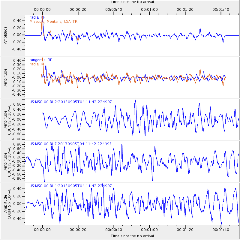
MSO Missoula, Montana, USA - Earthquake Result Viewer
*The percent match for this event was below the threshold and hence no stack was calculated.
| Earthquake location: |
Northern Mid-Atlantic Ridge |
| Earthquake latitude/longitude: |
15.2/-45.2 |
| Earthquake time(UTC): |
2013/09/05 (248) 04:01:36 GMT |
| Earthquake Depth: |
10 km |
| Earthquake Magnitude: |
6.0 MWW, 5.9 MWB, 6.0 MWW, 6.0 MWC |
| Earthquake Catalog/Contributor: |
NEIC PDE/NEIC COMCAT |
|
| Network: |
US United States National Seismic Network |
| Station: |
MSO Missoula, Montana, USA |
| Lat/Lon: |
46.83 N/113.94 W |
| Elevation: |
1264 m |
|
| Distance: |
64.5 deg |
| Az: |
314.88 deg |
| Baz: |
94.84 deg |
| Ray Param: |
$rayparam |
*The percent match for this event was below the threshold and hence was not used in the summary stack. |
|
| Radial Match: |
63.604336 % |
| Radial Bump: |
400 |
| Transverse Match: |
65.44959 % |
| Transverse Bump: |
400 |
| SOD ConfigId: |
626651 |
| Insert Time: |
2014-04-18 12:57:33.015 +0000 |
| GWidth: |
2.5 |
| Max Bumps: |
400 |
| Tol: |
0.001 |
|
Signal To Noise
| Channel | StoN | STA | LTA |
| US:MSO:00:BHZ:20130905T04:11:42.22499Z | 2.8009148 | 4.0736813E-7 | 1.4544109E-7 |
| US:MSO:00:BH1:20130905T04:11:42.22499Z | 1.7502418 | 1.5289174E-7 | 8.735464E-8 |
| US:MSO:00:BH2:20130905T04:11:42.22499Z | 1.2836751 | 2.541809E-7 | 1.980103E-7 |
| Arrivals |
| Ps | |
| PpPs | |
| PsPs/PpSs | |


