You are here: Home > Network List > II - Global Seismograph Network (GSN - IRIS/IDA) Stations List
> Station ARU Arti, Russia > Earthquake Result Viewer
ARU Arti, Russia - Earthquake Result Viewer
| Earthquake location: |
Taiwan Region |
| Earthquake latitude/longitude: |
21.9/121.5 |
| Earthquake time(UTC): |
1996/09/05 (249) 23:42:06 GMT |
| Earthquake Depth: |
20 km |
| Earthquake Magnitude: |
6.4 MB, 6.6 MS, 6.8 UNKNOWN, 6.8 ME |
| Earthquake Catalog/Contributor: |
WHDF/NEIC |
|
| Network: |
II Global Seismograph Network (GSN - IRIS/IDA) |
| Station: |
ARU Arti, Russia |
| Lat/Lon: |
56.43 N/58.56 E |
| Elevation: |
250 m |
|
| Distance: |
57.1 deg |
| Az: |
323.904 deg |
| Baz: |
99.969 deg |
| Ray Param: |
0.063679144 |
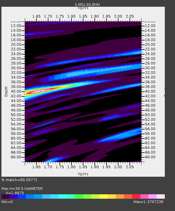
| Estimated Moho Depth: |
39.5 km |
| Estimated Crust Vp/Vs: |
1.67 |
| Assumed Crust Vp: |
6.159 km/s |
| Estimated Crust Vs: |
3.693 km/s |
| Estimated Crust Poisson's Ratio: |
0.22 |
|
| Radial Match: |
98.05771 % |
| Radial Bump: |
316 |
| Transverse Match: |
94.91935 % |
| Transverse Bump: |
400 |
| SOD ConfigId: |
6273 |
| Insert Time: |
2010-03-01 16:45:06.806 +0000 |
| GWidth: |
2.5 |
| Max Bumps: |
400 |
| Tol: |
0.001 |
|

Signal To Noise
| Channel | StoN | STA | LTA |
| II:ARU:00:BHN:19960905T23:51:20.060022Z | 6.578702 | 4.6311482E-7 | 7.039608E-8 |
| II:ARU:00:BHE:19960905T23:51:20.060022Z | 17.7731 | 1.8380017E-6 | 1.03414806E-7 |
| II:ARU:00:BHZ:19960905T23:51:20.060022Z | 33.791714 | 3.7549974E-6 | 1.11121835E-7 |
| Arrivals |
| Ps | 4.5 SECOND |
| PpPs | 16 SECOND |
| PsPs/PpSs | 21 SECOND |


