You are here: Home > Network List > UW - Pacific Northwest Regional Seismic Network Stations List
> Station MRBL Marblemount, WA, USA > Earthquake Result Viewer
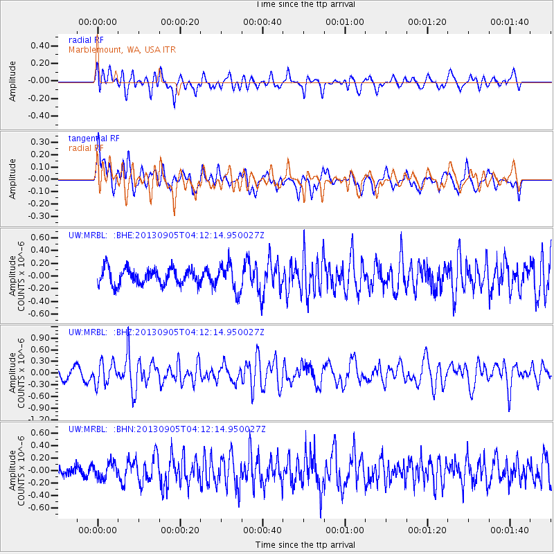
MRBL Marblemount, WA, USA - Earthquake Result Viewer
*The percent match for this event was below the threshold and hence no stack was calculated.
| Earthquake location: |
Northern Mid-Atlantic Ridge |
| Earthquake latitude/longitude: |
15.2/-45.2 |
| Earthquake time(UTC): |
2013/09/05 (248) 04:01:36 GMT |
| Earthquake Depth: |
10 km |
| Earthquake Magnitude: |
6.0 MWW, 5.9 MWB, 6.0 MWW, 6.0 MWC |
| Earthquake Catalog/Contributor: |
NEIC PDE/NEIC COMCAT |
|
| Network: |
UW Pacific Northwest Regional Seismic Network |
| Station: |
MRBL Marblemount, WA, USA |
| Lat/Lon: |
48.52 N/121.48 W |
| Elevation: |
75 m |
|
| Distance: |
69.7 deg |
| Az: |
316.48 deg |
| Baz: |
89.898 deg |
| Ray Param: |
$rayparam |
*The percent match for this event was below the threshold and hence was not used in the summary stack. |
|
| Radial Match: |
65.07414 % |
| Radial Bump: |
400 |
| Transverse Match: |
60.476837 % |
| Transverse Bump: |
400 |
| SOD ConfigId: |
626651 |
| Insert Time: |
2014-04-18 12:59:46.748 +0000 |
| GWidth: |
2.5 |
| Max Bumps: |
400 |
| Tol: |
0.001 |
|
Signal To Noise
| Channel | StoN | STA | LTA |
| UW:MRBL: :BHZ:20130905T04:12:14.950027Z | 2.4172397 | 2.872917E-7 | 1.1885115E-7 |
| UW:MRBL: :BHN:20130905T04:12:14.950027Z | 0.9132668 | 1.2278247E-7 | 1.3444316E-7 |
| UW:MRBL: :BHE:20130905T04:12:14.950027Z | 1.7372901 | 2.1973446E-7 | 1.2648115E-7 |
| Arrivals |
| Ps | |
| PpPs | |
| PsPs/PpSs | |


