You are here: Home > Network List > WU - The Southern Ontario Seismic Network Stations List
> Station PLIO Pelee Island, Stone Alvar Conservation Area, Ontario, Canada > Earthquake Result Viewer
PLIO Pelee Island, Stone Alvar Conservation Area, Ontario, Canada - Earthquake Result Viewer
| Earthquake location: |
Northern Mid-Atlantic Ridge |
| Earthquake latitude/longitude: |
15.2/-45.2 |
| Earthquake time(UTC): |
2013/09/05 (248) 04:01:36 GMT |
| Earthquake Depth: |
10 km |
| Earthquake Magnitude: |
6.0 MWW, 5.9 MWB, 6.0 MWW, 6.0 MWC |
| Earthquake Catalog/Contributor: |
NEIC PDE/NEIC COMCAT |
|
| Network: |
WU The Southern Ontario Seismic Network |
| Station: |
PLIO Pelee Island, Stone Alvar Conservation Area, Ontario, Canada |
| Lat/Lon: |
41.75 N/82.63 W |
| Elevation: |
143 m |
|
| Distance: |
41.7 deg |
| Az: |
316.91 deg |
| Baz: |
118.177 deg |
| Ray Param: |
0.07362691 |
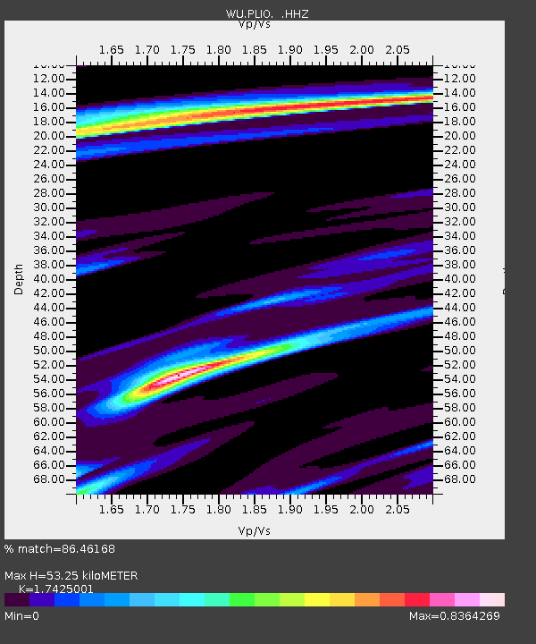
| Estimated Moho Depth: |
53.25 km |
| Estimated Crust Vp/Vs: |
1.74 |
| Assumed Crust Vp: |
6.498 km/s |
| Estimated Crust Vs: |
3.729 km/s |
| Estimated Crust Poisson's Ratio: |
0.25 |
|
| Radial Match: |
86.46168 % |
| Radial Bump: |
293 |
| Transverse Match: |
73.538895 % |
| Transverse Bump: |
400 |
| SOD ConfigId: |
626651 |
| Insert Time: |
2014-04-18 13:00:43.472 +0000 |
| GWidth: |
2.5 |
| Max Bumps: |
400 |
| Tol: |
0.001 |
|

Signal To Noise
| Channel | StoN | STA | LTA |
| WU:PLIO: :HHZ:20130905T04:08:54.309005Z | 6.7242455 | 1.365238E-6 | 2.0303213E-7 |
| WU:PLIO: :HHN:20130905T04:08:54.309005Z | 3.0369666 | 4.3547027E-7 | 1.4338987E-7 |
| WU:PLIO: :HHE:20130905T04:08:54.309005Z | 5.7579803 | 8.3041544E-7 | 1.4421992E-7 |
| Arrivals |
| Ps | 6.5 SECOND |
| PpPs | 21 SECOND |
| PsPs/PpSs | 27 SECOND |


