You are here: Home > Network List > CI - Caltech Regional Seismic Network Stations List
> Station TIN Tinemaha, Big Pine, CA, USA > Earthquake Result Viewer
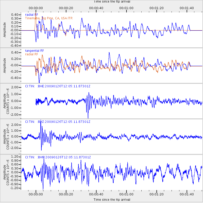
TIN Tinemaha, Big Pine, CA, USA - Earthquake Result Viewer
*The percent match for this event was below the threshold and hence no stack was calculated.
| Earthquake location: |
Fiji Islands Region |
| Earthquake latitude/longitude: |
-17.8/-178.6 |
| Earthquake time(UTC): |
2009/01/26 (026) 11:54:39 GMT |
| Earthquake Depth: |
580 km |
| Earthquake Magnitude: |
5.5 MB, 5.8 MW, 5.8 MW |
| Earthquake Catalog/Contributor: |
WHDF/NEIC |
|
| Network: |
CI Caltech Regional Seismic Network |
| Station: |
TIN Tinemaha, Big Pine, CA, USA |
| Lat/Lon: |
37.05 N/118.23 W |
| Elevation: |
1197 m |
|
| Distance: |
78.8 deg |
| Az: |
45.145 deg |
| Baz: |
237.59 deg |
| Ray Param: |
$rayparam |
*The percent match for this event was below the threshold and hence was not used in the summary stack. |
|
| Radial Match: |
59.344177 % |
| Radial Bump: |
400 |
| Transverse Match: |
50.210648 % |
| Transverse Bump: |
400 |
| SOD ConfigId: |
2658 |
| Insert Time: |
2010-02-25 20:51:56.260 +0000 |
| GWidth: |
2.5 |
| Max Bumps: |
400 |
| Tol: |
0.001 |
|
Signal To Noise
| Channel | StoN | STA | LTA |
| CI:TIN: :BHZ:20090126T12:05:11.87301Z | 4.186546 | 8.996391E-7 | 2.1488816E-7 |
| CI:TIN: :BHN:20090126T12:05:11.87301Z | 1.2709627 | 3.8652274E-7 | 3.041181E-7 |
| CI:TIN: :BHE:20090126T12:05:11.87301Z | 3.003268 | 6.390487E-7 | 2.1278444E-7 |
| Arrivals |
| Ps | |
| PpPs | |
| PsPs/PpSs | |


