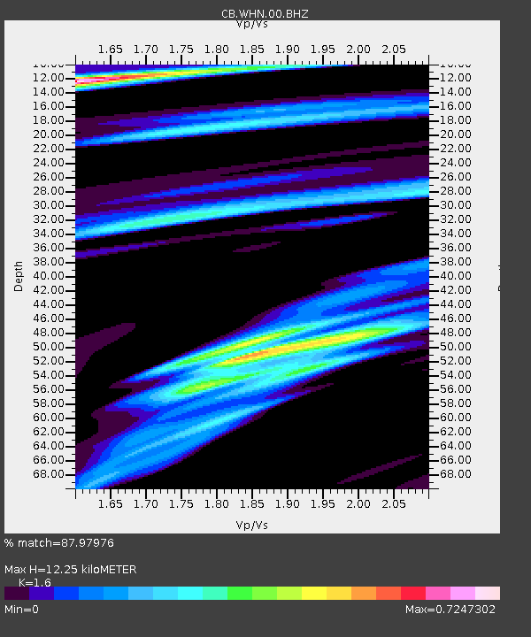
WHN Wuhantai,Hubei Province - Earthquake Result Viewer

Earthquake location: Andreanof Islands, Aleutian Is.
Earthquake latitude/longitude: 51.5/-174.6
Earthquake time(UTC): 2013/09/05 (248) 05:43:39 GMT
Earthquake Depth: 20 km
Earthquake Magnitude: 5.6 MWW, 5.4 MI, 5.5 MWB, 5.6 MWW, 5.7 MWC, 5.7 ML, 5.8 MWC
Earthquake Catalog/Contributor: NEIC PDE/NEIC COMCAT
Network: CB China National Seismic Network
Station: WHN Wuhantai,Hubei Province
Lat/Lon: 30.54 N/114.35 E
Elevation: 80 m
Distance: 55.3 deg
Az: 276.841 deg
Baz: 46.05 deg
Ray Param: 0.0648758
Estimated Moho Depth: 12.25 km
Estimated Crust Vp/Vs: 1.60
Assumed Crust Vp: 6.276 km/s
Estimated Crust Vs: 3.922 km/s
Estimated Crust Poisson's Ratio: 0.18
Radial Match: 87.97976 %
Radial Bump: 400
Transverse Match: 75.9819 %
Transverse Bump: 366
SOD ConfigId: 626651
Insert Time: 2014-04-18 13:04:39.776 +0000
GWidth: 2.5
Max Bumps: 400
Tol: 0.001

Signal To Noise

ChannelStoNSTALTA
CB:WHN:00:BHZ:20130905T05:52:40.500005Z7.90596961.2202141E-61.5434085E-7
CB:WHN:00:BHN:20130905T05:52:40.500005Z2.83876785.0930925E-71.7941208E-7
CB:WHN:00:BHE:20130905T05:52:40.500005Z2.61210183.3768708E-71.2927792E-7
Arrivals
Ps1.2 SECOND
PpPs4.8 SECOND
PsPs/PpSs6.0 SECOND