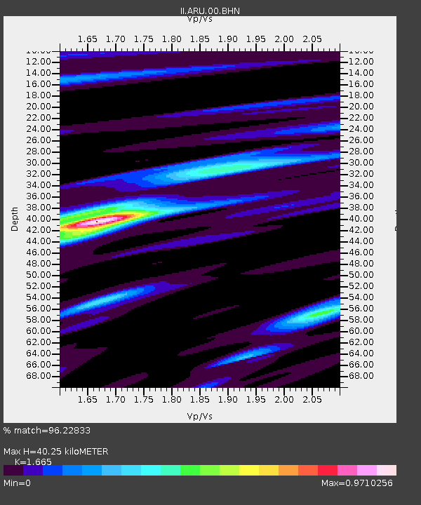
ARU Arti, Russia - Earthquake Result Viewer

Earthquake location: Irian Jaya Region, Indonesia
Earthquake latitude/longitude: -0.9/137.0
Earthquake time(UTC): 1996/02/17 (048) 05:59:29 GMT
Earthquake Depth: 33 km
Earthquake Magnitude: 6.5 MB, 8.1 MS, 7.9 UNKNOWN
Earthquake Catalog/Contributor: WHDF/NEIC
Network: II Global Seismograph Network (GSN - IRIS/IDA)
Station: ARU Arti, Russia
Lat/Lon: 56.43 N/58.56 E
Elevation: 250 m
Distance: 84.4 deg
Az: 326.845 deg
Baz: 100.151 deg
Ray Param: 0.04545827
Estimated Moho Depth: 40.25 km
Estimated Crust Vp/Vs: 1.66
Assumed Crust Vp: 6.159 km/s
Estimated Crust Vs: 3.699 km/s
Estimated Crust Poisson's Ratio: 0.22
Radial Match: 96.22833 %
Radial Bump: 299
Transverse Match: 93.78116 %
Transverse Bump: 400
SOD ConfigId: 6273
Insert Time: 2010-03-01 16:45:32.469 +0000
GWidth: 2.5
Max Bumps: 400
Tol: 0.001

Signal To Noise

ChannelStoNSTALTA
II:ARU:00:BHN:19960217T06:11:27.629016Z1.11249133.7976997E-73.4136897E-7
II:ARU:00:BHE:19960217T06:11:27.632007Z3.65071637.606027E-72.0834341E-7
II:ARU:00:BHZ:19960217T06:11:27.629016Z5.51600462.2700253E-64.1153433E-7
Arrivals
Ps4.5 SECOND
PpPs17 SECOND
PsPs/PpSs21 SECOND