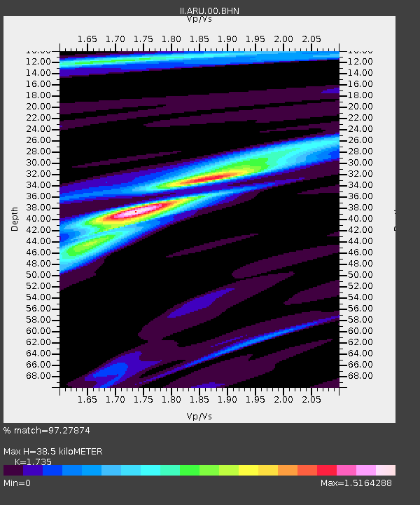
ARU Arti, Russia - Earthquake Result Viewer
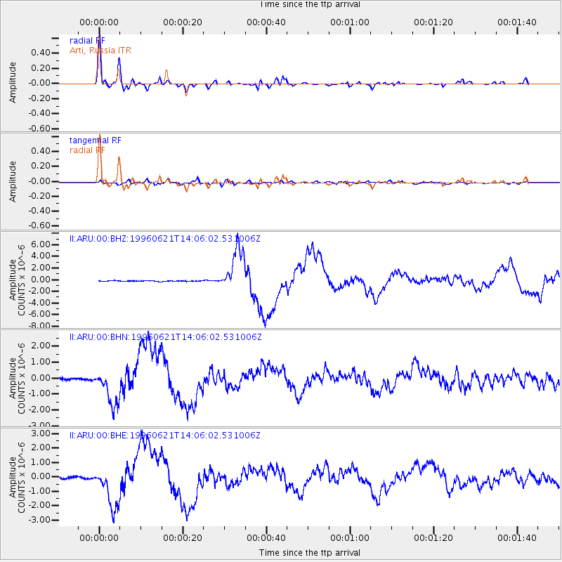
Earthquake location: Off East Coast Of Kamchatka
Earthquake latitude/longitude: 51.6/159.1
Earthquake time(UTC): 1996/06/21 (173) 13:57:10 GMT
Earthquake Depth: 20 km
Earthquake Magnitude: 6.0 MB, 6.6 MS, 7.0 UNKNOWN, 6.5 MS
Earthquake Catalog/Contributor: WHDF/NEIC
Network: II Global Seismograph Network (GSN - IRIS/IDA)
Station: ARU Arti, Russia
Lat/Lon: 56.43 N/58.56 E
Elevation: 250 m
Distance: 54.1 deg
Az: 317.619 deg
Baz: 49.227 deg
Ray Param: 0.065625064
Estimated Moho Depth: 38.5 km
Estimated Crust Vp/Vs: 1.74
Assumed Crust Vp: 6.159 km/s
Estimated Crust Vs: 3.55 km/s
Estimated Crust Poisson's Ratio: 0.25
Radial Match: 97.27874 %
Radial Bump: 400
Transverse Match: 74.635185 %
Transverse Bump: 400
SOD ConfigId: 6273
Insert Time: 2010-03-01 16:45:53.051 +0000
GWidth: 2.5
Max Bumps: 400
Tol: 0.001

Signal To Noise

ChannelStoNSTALTA
II:ARU:00:BHN:19960621T14:06:02.531006Z15.9046511.1479314E-67.217583E-8
II:ARU:00:BHE:19960621T14:06:02.531006Z19.1592671.4834098E-67.7425184E-8
II:ARU:00:BHZ:19960621T14:06:02.531006Z71.3803253.8210305E-65.353058E-8
Arrivals
Ps4.8 SECOND
PpPs16 SECOND
PsPs/PpSs21 SECOND