You are here: Home > Network List > XJ13 - CRAFTI Stations List
> Station LN14 Matela PS > Earthquake Result Viewer
LN14 Matela PS - Earthquake Result Viewer
| Earthquake location: |
Northern Molucca Sea |
| Earthquake latitude/longitude: |
1.9/126.5 |
| Earthquake time(UTC): |
2014/11/18 (322) 04:47:20 GMT |
| Earthquake Depth: |
65 km |
| Earthquake Magnitude: |
5.9 MB, 5.9 MWB |
| Earthquake Catalog/Contributor: |
NEIC PDE/NEIC COMCAT |
|
| Network: |
XJ CRAFTI |
| Station: |
LN14 Matela PS |
| Lat/Lon: |
2.44 S/36.42 E |
| Elevation: |
1631 m |
|
| Distance: |
90.2 deg |
| Az: |
267.581 deg |
| Baz: |
88.166 deg |
| Ray Param: |
0.041682024 |
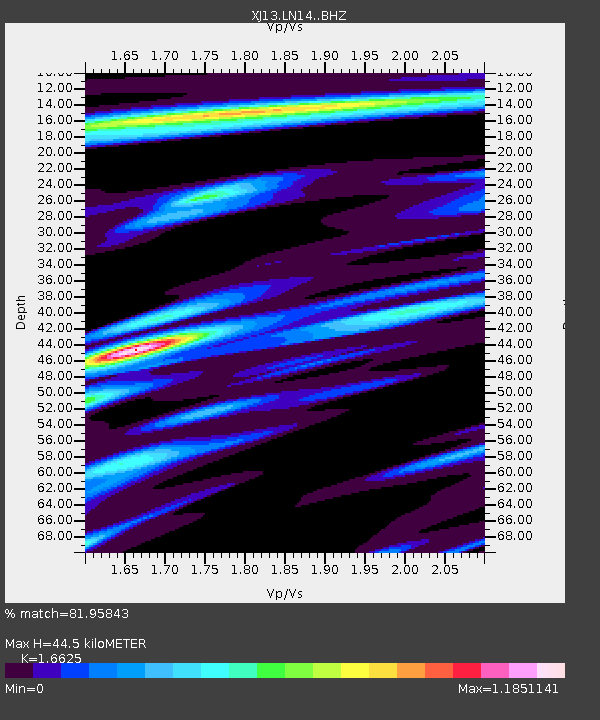
| Estimated Moho Depth: |
44.5 km |
| Estimated Crust Vp/Vs: |
1.66 |
| Assumed Crust Vp: |
6.601 km/s |
| Estimated Crust Vs: |
3.97 km/s |
| Estimated Crust Poisson's Ratio: |
0.22 |
|
| Radial Match: |
81.95843 % |
| Radial Bump: |
400 |
| Transverse Match: |
80.52398 % |
| Transverse Bump: |
400 |
| SOD ConfigId: |
3390531 |
| Insert Time: |
2019-04-15 02:33:19.605 +0000 |
| GWidth: |
2.5 |
| Max Bumps: |
400 |
| Tol: |
0.001 |
|

Signal To Noise
| Channel | StoN | STA | LTA |
| XJ:LN14: :BHZ:20141118T04:59:42.940024Z | 2.1036236 | 1.5938143E-7 | 7.576518E-8 |
| XJ:LN14: :BHN:20141118T04:59:42.940024Z | 0.89925414 | 4.9201923E-8 | 5.4714143E-8 |
| XJ:LN14: :BHE:20141118T04:59:42.940024Z | 0.86894935 | 5.9515028E-8 | 6.849079E-8 |
| Arrivals |
| Ps | 4.6 SECOND |
| PpPs | 18 SECOND |
| PsPs/PpSs | 22 SECOND |


