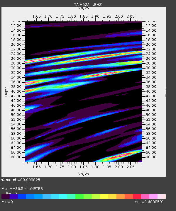
H52A Wyevale, ON, CAN - Earthquake Result Viewer

Earthquake location: Andreanof Islands, Aleutian Is.
Earthquake latitude/longitude: 51.5/-174.6
Earthquake time(UTC): 2013/09/05 (248) 05:43:39 GMT
Earthquake Depth: 20 km
Earthquake Magnitude: 5.6 MWW, 5.4 MI, 5.5 MWB, 5.6 MWW, 5.7 MWC, 5.7 ML, 5.8 MWC
Earthquake Catalog/Contributor: NEIC PDE/NEIC COMCAT
Network: TA USArray Transportable Network (new EarthScope stations)
Station: H52A Wyevale, ON, CAN
Lat/Lon: 44.64 N/79.89 W
Elevation: 209 m
Distance: 59.4 deg
Az: 55.792 deg
Baz: 313.554 deg
Ray Param: 0.0622233
Estimated Moho Depth: 36.5 km
Estimated Crust Vp/Vs: 1.60
Assumed Crust Vp: 6.577 km/s
Estimated Crust Vs: 4.111 km/s
Estimated Crust Poisson's Ratio: 0.18
Radial Match: 80.998825 %
Radial Bump: 400
Transverse Match: 69.81721 %
Transverse Bump: 400
SOD ConfigId: 626651
Insert Time: 2014-04-18 13:26:02.731 +0000
GWidth: 2.5
Max Bumps: 400
Tol: 0.001

Signal To Noise

ChannelStoNSTALTA
TA:H52A: :BHZ:20130905T05:53:09.22498Z4.1446951.276181E-63.079071E-7
TA:H52A: :BHN:20130905T05:53:09.22498Z2.71932157.5236255E-72.766729E-7
TA:H52A: :BHE:20130905T05:53:09.22498Z2.45814325.582597E-72.2710627E-7
Arrivals
Ps3.5 SECOND
PpPs14 SECOND
PsPs/PpSs17 SECOND