You are here: Home > Network List > TA - USArray Transportable Network (new EarthScope stations) Stations List
> Station O48A Farmland, IN, USA > Earthquake Result Viewer
O48A Farmland, IN, USA - Earthquake Result Viewer
*The percent match for this event was below the threshold and hence no stack was calculated.
| Earthquake location: |
Andreanof Islands, Aleutian Is. |
| Earthquake latitude/longitude: |
51.5/-174.6 |
| Earthquake time(UTC): |
2013/09/05 (248) 05:43:39 GMT |
| Earthquake Depth: |
20 km |
| Earthquake Magnitude: |
5.6 MWW, 5.4 MI, 5.5 MWB, 5.6 MWW, 5.7 MWC, 5.7 ML, 5.8 MWC |
| Earthquake Catalog/Contributor: |
NEIC PDE/NEIC COMCAT |
|
| Network: |
TA USArray Transportable Network (new EarthScope stations) |
| Station: |
O48A Farmland, IN, USA |
| Lat/Lon: |
40.26 N/85.16 W |
| Elevation: |
300 m |
|
| Distance: |
59.5 deg |
| Az: |
62.597 deg |
| Baz: |
313.471 deg |
| Ray Param: |
$rayparam |
*The percent match for this event was below the threshold and hence was not used in the summary stack. |
|
| Radial Match: |
71.94425 % |
| Radial Bump: |
400 |
| Transverse Match: |
71.00258 % |
| Transverse Bump: |
400 |
| SOD ConfigId: |
626651 |
| Insert Time: |
2014-04-18 13:30:32.290 +0000 |
| GWidth: |
2.5 |
| Max Bumps: |
400 |
| Tol: |
0.001 |
|
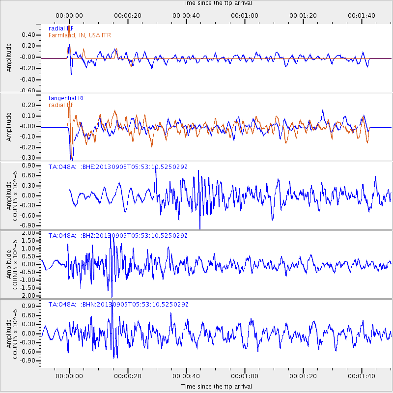
Signal To Noise
| Channel | StoN | STA | LTA |
| TA:O48A: :BHZ:20130905T05:53:10.525029Z | 2.0099497 | 5.4517574E-7 | 2.712385E-7 |
| TA:O48A: :BHN:20130905T05:53:10.525029Z | 1.1755456 | 2.2752086E-7 | 1.9354489E-7 |
| TA:O48A: :BHE:20130905T05:53:10.525029Z | 1.7519753 | 3.032719E-7 | 1.7310283E-7 |
| Arrivals |
| Ps | |
| PpPs | |
| PsPs/PpSs | |


