P56A Dayton Farm, Ripley, WV, USA - Earthquake Result Viewer
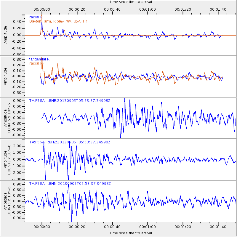
Earthquake location: Andreanof Islands, Aleutian Is.
Earthquake latitude/longitude: 51.5/-174.6
Earthquake time(UTC): 2013/09/05 (248) 05:43:39 GMT
Earthquake Depth: 20 km
Earthquake Magnitude: 5.6 MWW, 5.4 MI, 5.5 MWB, 5.6 MWW, 5.7 MWC, 5.7 ML, 5.8 MWC
Earthquake Catalog/Contributor: NEIC PDE/NEIC COMCAT
Network: TA USArray Transportable Network (new EarthScope stations)
Station: P56A Dayton Farm, Ripley, WV, USA
Lat/Lon: 39.50 N/78.84 W
Elevation: 249 m
Distance: 63.5 deg
Az: 59.316 deg
Baz: 315.942 deg
Ray Param: 0.059501365
Estimated Moho Depth: 69.25 km
Estimated Crust Vp/Vs: 1.77
Assumed Crust Vp: 6.159 km/s
Estimated Crust Vs: 3.47 km/s
Estimated Crust Poisson's Ratio: 0.27
Radial Match: 84.32615 %
Radial Bump: 400
Transverse Match: 66.286 %
Transverse Bump: 400
SOD ConfigId: 626651
Insert Time: 2014-04-18 13:31:30.339 +0000
GWidth: 2.5
Max Bumps: 400
Tol: 0.001

Signal To Noise

ChannelStoNSTALTA
TA:P56A: :BHZ:20130905T05:53:37.34998Z7.70310451.1245415E-61.459855E-7
TA:P56A: :BHN:20130905T05:53:37.34998Z1.84039142.1477432E-71.1670035E-7
TA:P56A: :BHE:20130905T05:53:37.34998Z2.13382822.8358372E-71.3289905E-7
Arrivals
Ps9.1 SECOND
PpPs30 SECOND
PsPs/PpSs39 SECOND