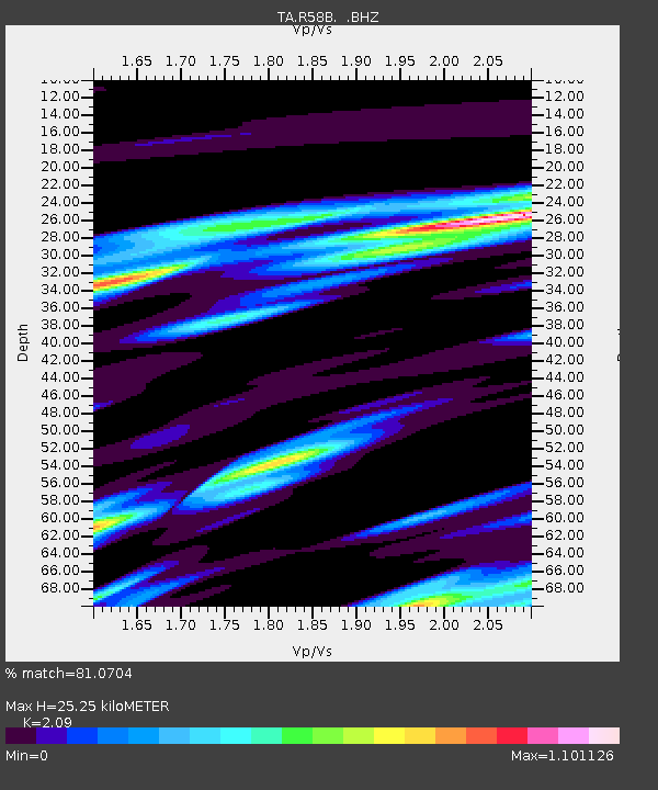
R58B Mineral, VA, USA - Earthquake Result Viewer
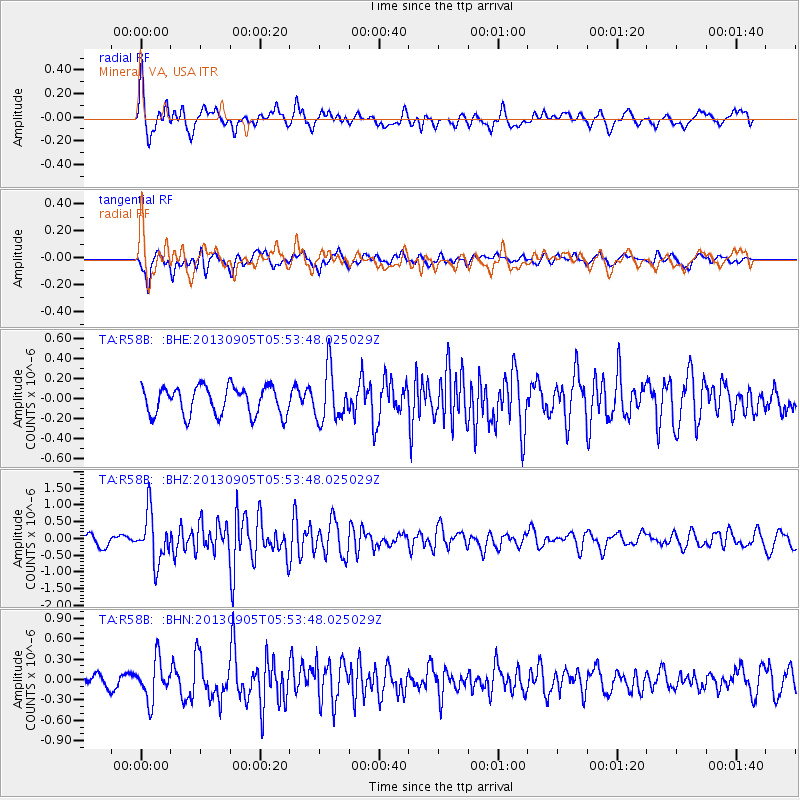
Earthquake location: Andreanof Islands, Aleutian Is.
Earthquake latitude/longitude: 51.5/-174.6
Earthquake time(UTC): 2013/09/05 (248) 05:43:39 GMT
Earthquake Depth: 20 km
Earthquake Magnitude: 5.6 MWW, 5.4 MI, 5.5 MWB, 5.6 MWW, 5.7 MWC, 5.7 ML, 5.8 MWC
Earthquake Catalog/Contributor: NEIC PDE/NEIC COMCAT
Network: TA USArray Transportable Network (new EarthScope stations)
Station: R58B Mineral, VA, USA
Lat/Lon: 37.96 N/77.88 W
Elevation: 116 m
Distance: 65.2 deg
Az: 59.891 deg
Baz: 316.79 deg
Ray Param: 0.05843757
Estimated Moho Depth: 25.25 km
Estimated Crust Vp/Vs: 2.09
Assumed Crust Vp: 6.565 km/s
Estimated Crust Vs: 3.141 km/s
Estimated Crust Poisson's Ratio: 0.35
Radial Match: 81.0704 %
Radial Bump: 400
Transverse Match: 69.253494 %
Transverse Bump: 400
SOD ConfigId: 626651
Insert Time: 2014-04-18 13:32:43.945 +0000
GWidth: 2.5
Max Bumps: 400
Tol: 0.001

Signal To Noise

ChannelStoNSTALTA
TA:R58B: :BHZ:20130905T05:53:48.025029Z4.1125397.2875633E-71.7720353E-7
TA:R58B: :BHN:20130905T05:53:48.025029Z2.24563882.9057043E-71.2939323E-7
TA:R58B: :BHE:20130905T05:53:48.025029Z1.8102132.5523283E-71.4099602E-7
Arrivals
Ps4.4 SECOND
PpPs11 SECOND
PsPs/PpSs16 SECOND