You are here: Home > Network List > CI - Caltech Regional Seismic Network Stations List
> Station TIN Tinemaha, Big Pine, CA, USA > Earthquake Result Viewer
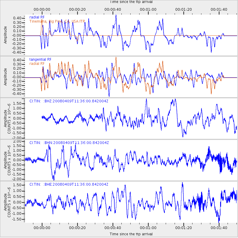
TIN Tinemaha, Big Pine, CA, USA - Earthquake Result Viewer
*The percent match for this event was below the threshold and hence no stack was calculated.
| Earthquake location: |
Loyalty Islands |
| Earthquake latitude/longitude: |
-20.2/168.9 |
| Earthquake time(UTC): |
2008/04/09 (100) 11:23:40 GMT |
| Earthquake Depth: |
35 km |
| Earthquake Magnitude: |
5.7 MB, 6.3 MW, 6.3 MW |
| Earthquake Catalog/Contributor: |
WHDF/NEIC |
|
| Network: |
CI Caltech Regional Seismic Network |
| Station: |
TIN Tinemaha, Big Pine, CA, USA |
| Lat/Lon: |
37.05 N/118.23 W |
| Elevation: |
1197 m |
|
| Distance: |
89.1 deg |
| Az: |
49.87 deg |
| Baz: |
243.863 deg |
| Ray Param: |
$rayparam |
*The percent match for this event was below the threshold and hence was not used in the summary stack. |
|
| Radial Match: |
69.307106 % |
| Radial Bump: |
400 |
| Transverse Match: |
72.47051 % |
| Transverse Bump: |
400 |
| SOD ConfigId: |
2504 |
| Insert Time: |
2010-02-25 20:51:59.523 +0000 |
| GWidth: |
2.5 |
| Max Bumps: |
400 |
| Tol: |
0.001 |
|
Signal To Noise
| Channel | StoN | STA | LTA |
| CI:TIN: :BHN:20080409T11:36:00.842004Z | 4.435532 | 7.4304285E-7 | 1.6752057E-7 |
| CI:TIN: :BHE:20080409T11:36:00.842004Z | 1.5076914 | 3.398782E-7 | 2.2542956E-7 |
| CI:TIN: :BHZ:20080409T11:36:00.842004Z | 1.3652481 | 3.5726205E-7 | 2.6168289E-7 |
| Arrivals |
| Ps | |
| PpPs | |
| PsPs/PpSs | |


