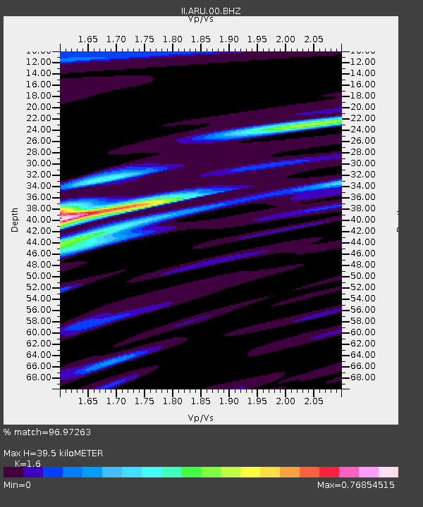
ARU Arti, Russia - Earthquake Result Viewer

Earthquake location: Southern Sumatra, Indonesia
Earthquake latitude/longitude: -2.0/100.1
Earthquake time(UTC): 2007/09/20 (263) 08:31:14 GMT
Earthquake Depth: 30 km
Earthquake Magnitude: 6.3 MB, 6.8 MS, 6.7 MW, 6.3 ME
Earthquake Catalog/Contributor: WHDF/NEIC
Network: II Global Seismograph Network (GSN - IRIS/IDA)
Station: ARU Arti, Russia
Lat/Lon: 56.43 N/58.56 E
Elevation: 250 m
Distance: 67.3 deg
Az: 336.438 deg
Baz: 134.017 deg
Ray Param: 0.05702635
Estimated Moho Depth: 39.5 km
Estimated Crust Vp/Vs: 1.60
Assumed Crust Vp: 6.159 km/s
Estimated Crust Vs: 3.849 km/s
Estimated Crust Poisson's Ratio: 0.18
Radial Match: 96.97263 %
Radial Bump: 382
Transverse Match: 87.922356 %
Transverse Bump: 400
SOD ConfigId: 2564
Insert Time: 2010-03-01 16:47:17.058 +0000
GWidth: 2.5
Max Bumps: 400
Tol: 0.001

Signal To Noise

ChannelStoNSTALTA
II:ARU:00:BHN:20070920T08:41:35.180002Z2.5672843.032192E-71.1810894E-7
II:ARU:00:BHE:20070920T08:41:35.180002Z2.07687542.750828E-71.3245031E-7
II:ARU:00:BHZ:20070920T08:41:35.180002Z6.92663679.2769005E-71.339308E-7
Arrivals
Ps4.0 SECOND
PpPs16 SECOND
PsPs/PpSs20 SECOND