You are here: Home > Network List > TA - USArray Transportable Network (new EarthScope stations) Stations List
> Station Y60A Bolivia, NC, USA > Earthquake Result Viewer
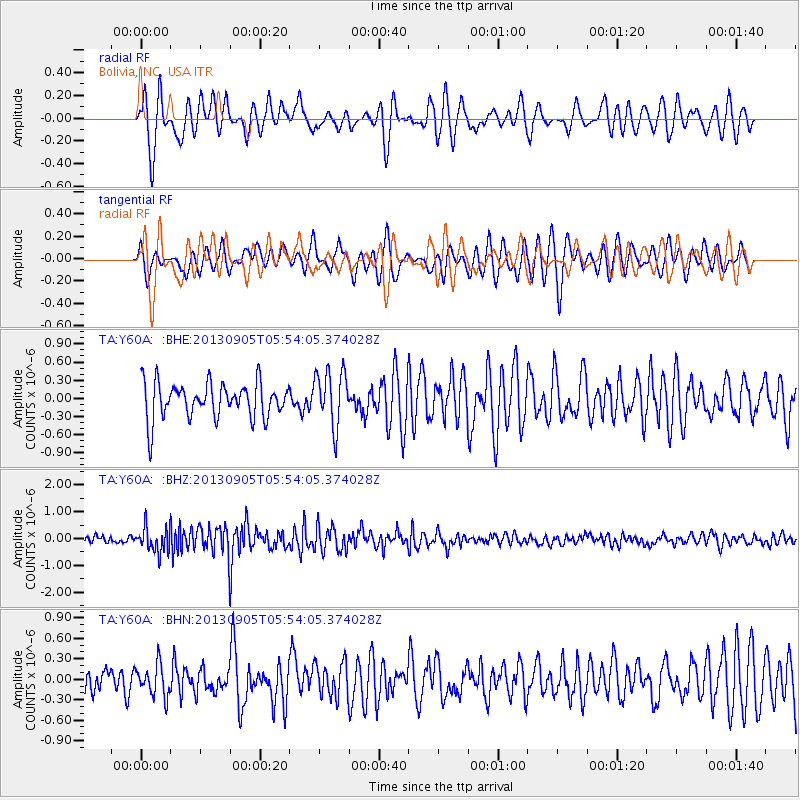
Y60A Bolivia, NC, USA - Earthquake Result Viewer
*The percent match for this event was below the threshold and hence no stack was calculated.
| Earthquake location: |
Andreanof Islands, Aleutian Is. |
| Earthquake latitude/longitude: |
51.5/-174.6 |
| Earthquake time(UTC): |
2013/09/05 (248) 05:43:39 GMT |
| Earthquake Depth: |
20 km |
| Earthquake Magnitude: |
5.6 MWW, 5.4 MI, 5.5 MWB, 5.6 MWW, 5.7 MWC, 5.7 ML, 5.8 MWC |
| Earthquake Catalog/Contributor: |
NEIC PDE/NEIC COMCAT |
|
| Network: |
TA USArray Transportable Network (new EarthScope stations) |
| Station: |
Y60A Bolivia, NC, USA |
| Lat/Lon: |
34.00 N/78.22 W |
| Elevation: |
7.0 m |
|
| Distance: |
67.9 deg |
| Az: |
63.03 deg |
| Baz: |
317.844 deg |
| Ray Param: |
$rayparam |
*The percent match for this event was below the threshold and hence was not used in the summary stack. |
|
| Radial Match: |
66.99761 % |
| Radial Bump: |
400 |
| Transverse Match: |
53.382828 % |
| Transverse Bump: |
400 |
| SOD ConfigId: |
626651 |
| Insert Time: |
2014-04-18 13:36:48.333 +0000 |
| GWidth: |
2.5 |
| Max Bumps: |
400 |
| Tol: |
0.001 |
|
Signal To Noise
| Channel | StoN | STA | LTA |
| TA:Y60A: :BHZ:20130905T05:54:05.374028Z | 3.3074706 | 4.5426387E-7 | 1.373448E-7 |
| TA:Y60A: :BHN:20130905T05:54:05.374028Z | 1.1987923 | 2.338801E-7 | 1.9509643E-7 |
| TA:Y60A: :BHE:20130905T05:54:05.374028Z | 1.5666305 | 4.5807133E-7 | 2.9239268E-7 |
| Arrivals |
| Ps | |
| PpPs | |
| PsPs/PpSs | |


