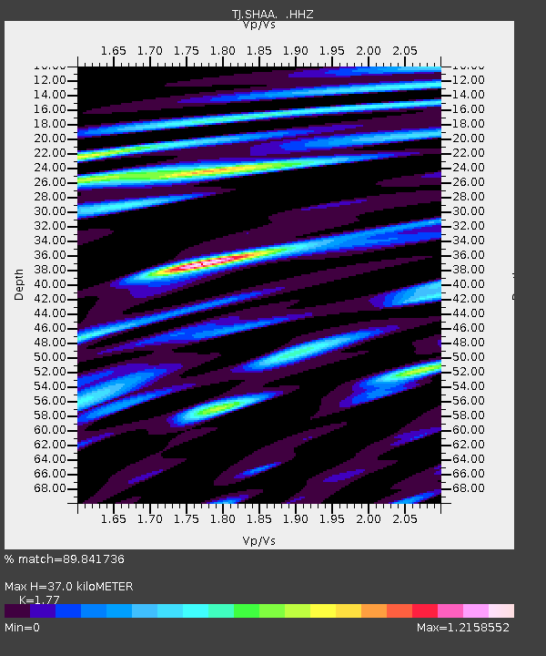
SHAA Shaartuz, Tajikistan - Earthquake Result Viewer
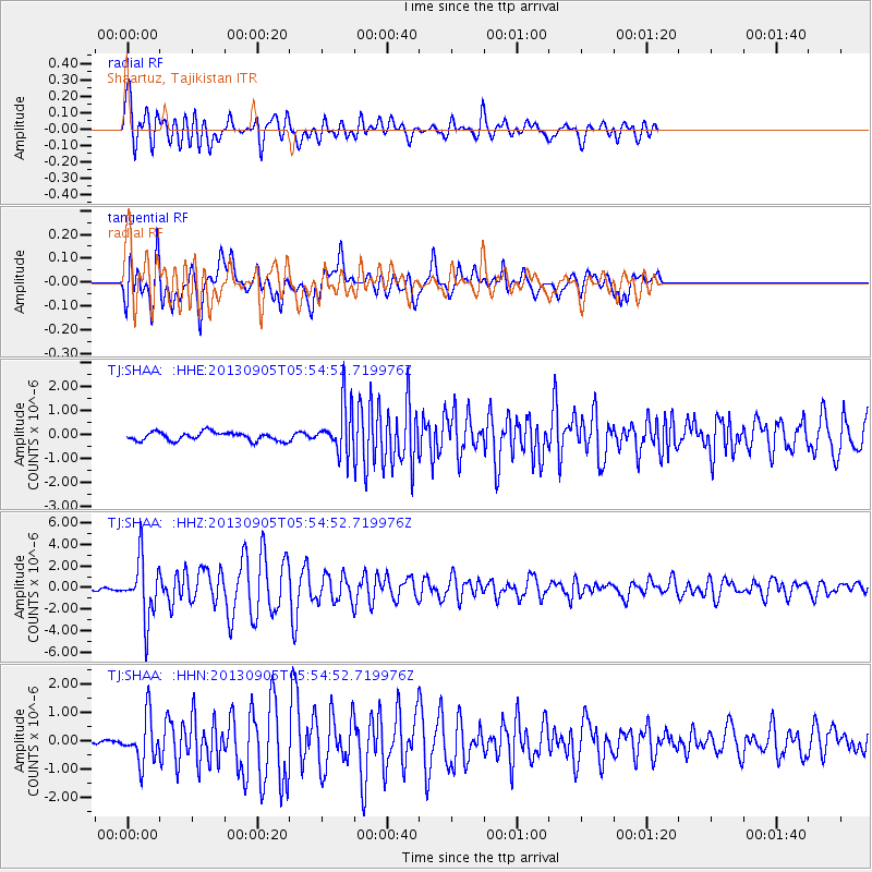
Earthquake location: Andreanof Islands, Aleutian Is.
Earthquake latitude/longitude: 51.5/-174.6
Earthquake time(UTC): 2013/09/05 (248) 05:43:39 GMT
Earthquake Depth: 20 km
Earthquake Magnitude: 5.6 MWW, 5.4 MI, 5.5 MWB, 5.6 MWW, 5.7 MWC, 5.7 ML, 5.8 MWC
Earthquake Catalog/Contributor: NEIC PDE/NEIC COMCAT
Network: TJ Tajikistan National Seismic Network
Station: SHAA Shaartuz, Tajikistan
Lat/Lon: 37.56 N/68.12 E
Elevation: 868 m
Distance: 75.8 deg
Az: 313.238 deg
Baz: 34.995 deg
Ray Param: 0.051418312
Estimated Moho Depth: 37.0 km
Estimated Crust Vp/Vs: 1.77
Assumed Crust Vp: 6.213 km/s
Estimated Crust Vs: 3.51 km/s
Estimated Crust Poisson's Ratio: 0.27
Radial Match: 89.841736 %
Radial Bump: 400
Transverse Match: 79.712326 %
Transverse Bump: 400
SOD ConfigId: 626651
Insert Time: 2014-04-18 13:37:26.708 +0000
GWidth: 2.5
Max Bumps: 400
Tol: 0.001

Signal To Noise

ChannelStoNSTALTA
TJ:SHAA: :HHZ:20130905T05:54:52.719976Z18.8145662.7289318E-61.4504359E-7
TJ:SHAA: :HHN:20130905T05:54:52.719976Z8.4917337.917274E-79.323509E-8
TJ:SHAA: :HHE:20130905T05:54:52.719976Z5.67548371.0093299E-61.7784035E-7
Arrivals
Ps4.7 SECOND
PpPs16 SECOND
PsPs/PpSs21 SECOND