You are here: Home > Network List > TA - USArray Transportable Network (new EarthScope stations) Stations List
> Station 121A Cookes Peak, Deming, NM, USA > Earthquake Result Viewer
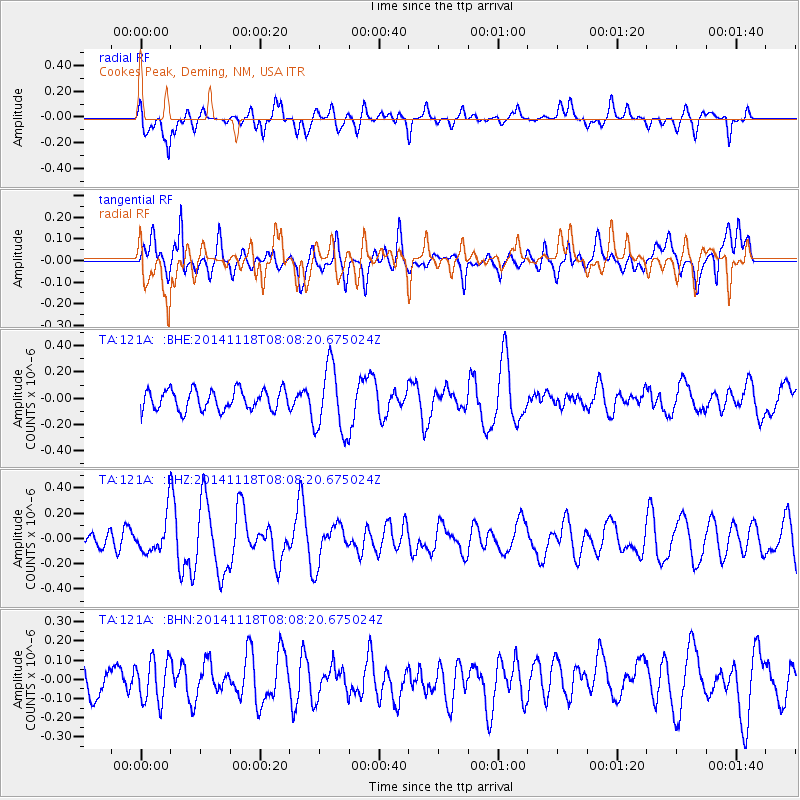
121A Cookes Peak, Deming, NM, USA - Earthquake Result Viewer
*The percent match for this event was below the threshold and hence no stack was calculated.
| Earthquake location: |
Northern Mid-Atlantic Ridge |
| Earthquake latitude/longitude: |
31.6/-40.8 |
| Earthquake time(UTC): |
2014/11/18 (322) 07:59:14 GMT |
| Earthquake Depth: |
10 km |
| Earthquake Magnitude: |
5.4 MW, 5.0 mb, 4.7 MS |
| Earthquake Catalog/Contributor: |
ISC/ISC |
|
| Network: |
TA USArray Transportable Network (new EarthScope stations) |
| Station: |
121A Cookes Peak, Deming, NM, USA |
| Lat/Lon: |
32.53 N/107.79 W |
| Elevation: |
1652 m |
|
| Distance: |
55.9 deg |
| Az: |
290.061 deg |
| Baz: |
71.507 deg |
| Ray Param: |
$rayparam |
*The percent match for this event was below the threshold and hence was not used in the summary stack. |
|
| Radial Match: |
61.24205 % |
| Radial Bump: |
400 |
| Transverse Match: |
57.63357 % |
| Transverse Bump: |
400 |
| SOD ConfigId: |
3390531 |
| Insert Time: |
2019-04-15 02:41:29.392 +0000 |
| GWidth: |
2.5 |
| Max Bumps: |
400 |
| Tol: |
0.001 |
|
Signal To Noise
| Channel | StoN | STA | LTA |
| TA:121A: :BHZ:20141118T08:08:20.675024Z | 1.36071 | 1.5265574E-7 | 1.1218831E-7 |
| TA:121A: :BHN:20141118T08:08:20.675024Z | 1.5213424 | 1.11267894E-7 | 7.313797E-8 |
| TA:121A: :BHE:20141118T08:08:20.675024Z | 3.299817 | 2.5599445E-7 | 7.757838E-8 |
| Arrivals |
| Ps | |
| PpPs | |
| PsPs/PpSs | |


