You are here: Home > Network List > TA - USArray Transportable Network (new EarthScope stations) Stations List
> Station C40A Isle Royale National Park, MI, USA > Earthquake Result Viewer
C40A Isle Royale National Park, MI, USA - Earthquake Result Viewer
| Earthquake location: |
Off Coast Of Costa Rica |
| Earthquake latitude/longitude: |
10.6/-86.1 |
| Earthquake time(UTC): |
2013/09/05 (248) 12:29:15 GMT |
| Earthquake Depth: |
19 km |
| Earthquake Magnitude: |
5.9 MWW, 5.7 MWB, 5.9 MWW, 5.9 MWC |
| Earthquake Catalog/Contributor: |
NEIC PDE/NEIC COMCAT |
|
| Network: |
TA USArray Transportable Network (new EarthScope stations) |
| Station: |
C40A Isle Royale National Park, MI, USA |
| Lat/Lon: |
47.92 N/89.15 W |
| Elevation: |
216 m |
|
| Distance: |
37.3 deg |
| Az: |
356.611 deg |
| Baz: |
175.043 deg |
| Ray Param: |
0.07619833 |
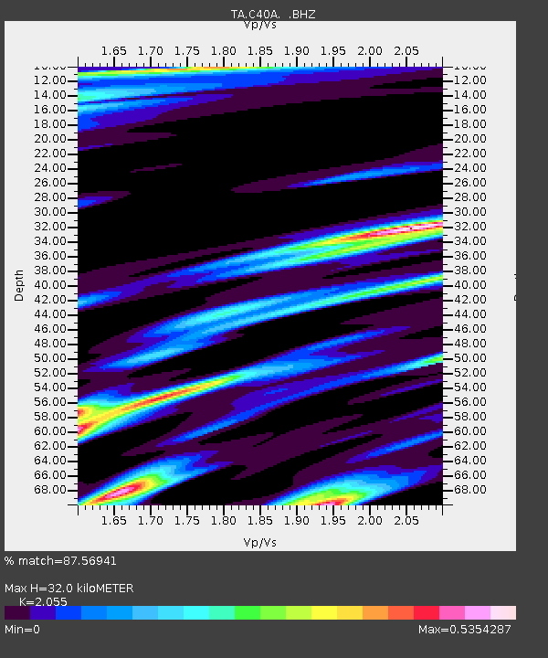
| Estimated Moho Depth: |
32.0 km |
| Estimated Crust Vp/Vs: |
2.06 |
| Assumed Crust Vp: |
6.467 km/s |
| Estimated Crust Vs: |
3.147 km/s |
| Estimated Crust Poisson's Ratio: |
0.34 |
|
| Radial Match: |
87.56941 % |
| Radial Bump: |
332 |
| Transverse Match: |
60.661945 % |
| Transverse Bump: |
400 |
| SOD ConfigId: |
626651 |
| Insert Time: |
2014-04-18 14:00:15.149 +0000 |
| GWidth: |
2.5 |
| Max Bumps: |
400 |
| Tol: |
0.001 |
|
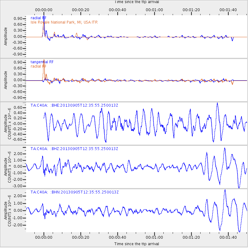
Signal To Noise
| Channel | StoN | STA | LTA |
| TA:C40A: :BHZ:20130905T12:35:55.250013Z | 3.5296686 | 7.5626906E-7 | 2.1426065E-7 |
| TA:C40A: :BHN:20130905T12:35:55.250013Z | 2.6494877 | 4.626904E-7 | 1.746339E-7 |
| TA:C40A: :BHE:20130905T12:35:55.250013Z | 1.817901 | 4.2400515E-7 | 2.3323885E-7 |
| Arrivals |
| Ps | 5.6 SECOND |
| PpPs | 14 SECOND |
| PsPs/PpSs | 20 SECOND |


