You are here: Home > Network List > TA - USArray Transportable Network (new EarthScope stations) Stations List
> Station E38A The Farm, Brule, WI, USA > Earthquake Result Viewer
E38A The Farm, Brule, WI, USA - Earthquake Result Viewer
| Earthquake location: |
Off Coast Of Costa Rica |
| Earthquake latitude/longitude: |
10.6/-86.1 |
| Earthquake time(UTC): |
2013/09/05 (248) 12:29:15 GMT |
| Earthquake Depth: |
19 km |
| Earthquake Magnitude: |
5.9 MWW, 5.7 MWB, 5.9 MWW, 5.9 MWC |
| Earthquake Catalog/Contributor: |
NEIC PDE/NEIC COMCAT |
|
| Network: |
TA USArray Transportable Network (new EarthScope stations) |
| Station: |
E38A The Farm, Brule, WI, USA |
| Lat/Lon: |
46.61 N/91.55 W |
| Elevation: |
341 m |
|
| Distance: |
36.2 deg |
| Az: |
353.627 deg |
| Baz: |
170.892 deg |
| Ray Param: |
0.07679742 |
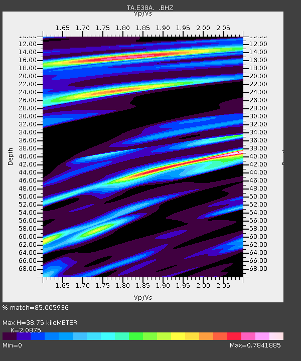
| Estimated Moho Depth: |
38.75 km |
| Estimated Crust Vp/Vs: |
2.09 |
| Assumed Crust Vp: |
6.467 km/s |
| Estimated Crust Vs: |
3.098 km/s |
| Estimated Crust Poisson's Ratio: |
0.35 |
|
| Radial Match: |
85.005936 % |
| Radial Bump: |
305 |
| Transverse Match: |
50.47856 % |
| Transverse Bump: |
400 |
| SOD ConfigId: |
626651 |
| Insert Time: |
2014-04-18 14:00:58.832 +0000 |
| GWidth: |
2.5 |
| Max Bumps: |
400 |
| Tol: |
0.001 |
|

Signal To Noise
| Channel | StoN | STA | LTA |
| TA:E38A: :BHZ:20130905T12:35:45.900007Z | 6.778983 | 1.3513302E-6 | 1.9934113E-7 |
| TA:E38A: :BHN:20130905T12:35:45.900007Z | 4.4292912 | 8.3399743E-7 | 1.882914E-7 |
| TA:E38A: :BHE:20130905T12:35:45.900007Z | 1.3373796 | 2.589556E-7 | 1.936291E-7 |
| Arrivals |
| Ps | 6.9 SECOND |
| PpPs | 17 SECOND |
| PsPs/PpSs | 24 SECOND |


