You are here: Home > Network List > TA - USArray Transportable Network (new EarthScope stations) Stations List
> Station I23K Minto, Yukon-Koyukuk, AK, USA > Earthquake Result Viewer
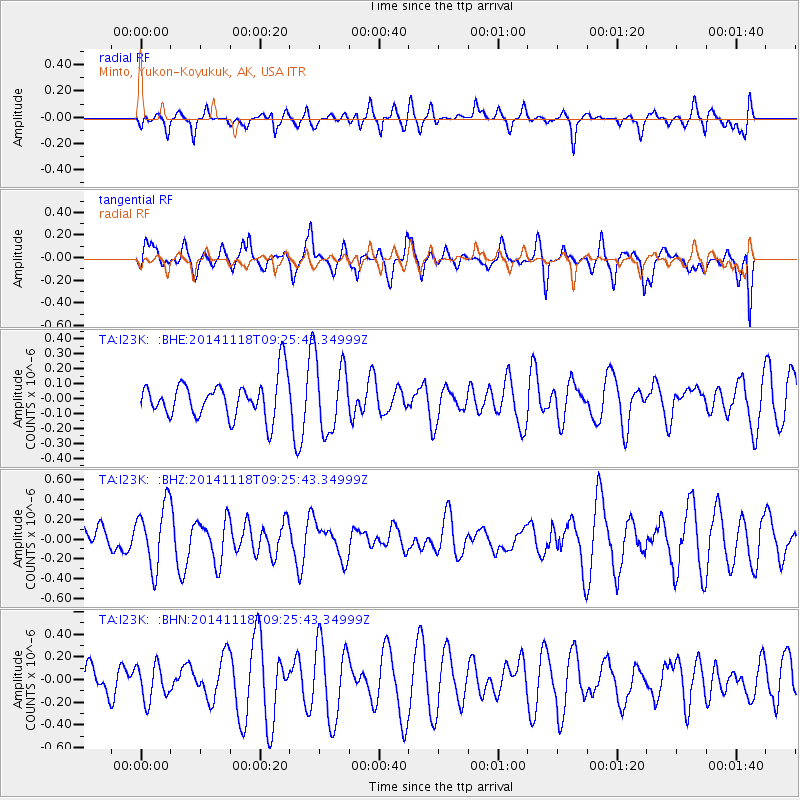
I23K Minto, Yukon-Koyukuk, AK, USA - Earthquake Result Viewer
*The percent match for this event was below the threshold and hence no stack was calculated.
| Earthquake location: |
Philippine Islands Region |
| Earthquake latitude/longitude: |
19.5/120.5 |
| Earthquake time(UTC): |
2014/11/18 (322) 09:14:49 GMT |
| Earthquake Depth: |
23 km |
| Earthquake Magnitude: |
4.9 mb, 4.8 mb |
| Earthquake Catalog/Contributor: |
ISC/ISC |
|
| Network: |
TA USArray Transportable Network (new EarthScope stations) |
| Station: |
I23K Minto, Yukon-Koyukuk, AK, USA |
| Lat/Lon: |
65.15 N/149.36 W |
| Elevation: |
149 m |
|
| Distance: |
72.5 deg |
| Az: |
26.299 deg |
| Baz: |
278.621 deg |
| Ray Param: |
$rayparam |
*The percent match for this event was below the threshold and hence was not used in the summary stack. |
|
| Radial Match: |
43.814117 % |
| Radial Bump: |
394 |
| Transverse Match: |
52.29385 % |
| Transverse Bump: |
400 |
| SOD ConfigId: |
3390531 |
| Insert Time: |
2019-04-15 02:49:06.329 +0000 |
| GWidth: |
2.5 |
| Max Bumps: |
400 |
| Tol: |
0.001 |
|
Signal To Noise
| Channel | StoN | STA | LTA |
| TA:I23K: :BHZ:20141118T09:25:43.34999Z | 2.7497191 | 3.1722774E-7 | 1.15367314E-7 |
| TA:I23K: :BHN:20141118T09:25:43.34999Z | 0.6516008 | 1.563322E-7 | 2.399202E-7 |
| TA:I23K: :BHE:20141118T09:25:43.34999Z | 1.8630965 | 2.3559213E-7 | 1.2645192E-7 |
| Arrivals |
| Ps | |
| PpPs | |
| PsPs/PpSs | |


