You are here: Home > Network List > TA - USArray Transportable Network (new EarthScope stations) Stations List
> Station G54A Lake Saint Peter, ON, CAN > Earthquake Result Viewer
G54A Lake Saint Peter, ON, CAN - Earthquake Result Viewer
| Earthquake location: |
Off Coast Of Costa Rica |
| Earthquake latitude/longitude: |
10.6/-86.1 |
| Earthquake time(UTC): |
2013/09/05 (248) 12:29:15 GMT |
| Earthquake Depth: |
19 km |
| Earthquake Magnitude: |
5.9 MWW, 5.7 MWB, 5.9 MWW, 5.9 MWC |
| Earthquake Catalog/Contributor: |
NEIC PDE/NEIC COMCAT |
|
| Network: |
TA USArray Transportable Network (new EarthScope stations) |
| Station: |
G54A Lake Saint Peter, ON, CAN |
| Lat/Lon: |
45.40 N/78.09 W |
| Elevation: |
465 m |
|
| Distance: |
35.4 deg |
| Az: |
9.77 deg |
| Baz: |
193.697 deg |
| Ray Param: |
0.07724856 |
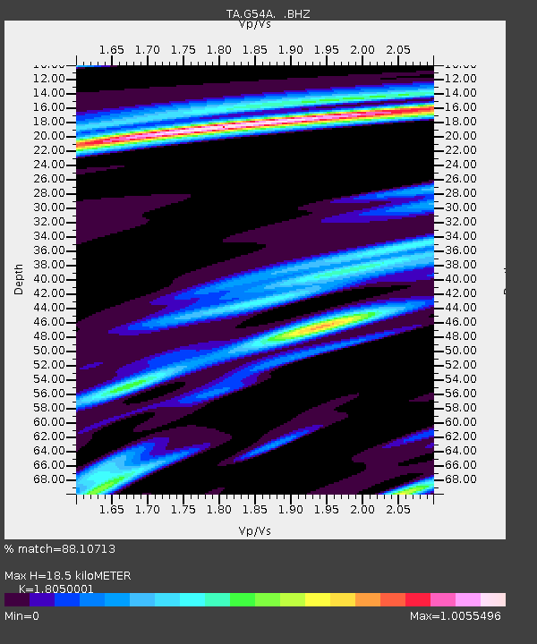
| Estimated Moho Depth: |
18.5 km |
| Estimated Crust Vp/Vs: |
1.81 |
| Assumed Crust Vp: |
6.577 km/s |
| Estimated Crust Vs: |
3.644 km/s |
| Estimated Crust Poisson's Ratio: |
0.28 |
|
| Radial Match: |
88.10713 % |
| Radial Bump: |
309 |
| Transverse Match: |
47.98237 % |
| Transverse Bump: |
400 |
| SOD ConfigId: |
626651 |
| Insert Time: |
2014-04-18 14:02:32.258 +0000 |
| GWidth: |
2.5 |
| Max Bumps: |
400 |
| Tol: |
0.001 |
|

Signal To Noise
| Channel | StoN | STA | LTA |
| TA:G54A: :BHZ:20130905T12:35:38.775007Z | 4.763979 | 9.512451E-7 | 1.996745E-7 |
| TA:G54A: :BHN:20130905T12:35:38.775007Z | 4.3826866 | 7.1410756E-7 | 1.6293832E-7 |
| TA:G54A: :BHE:20130905T12:35:38.775007Z | 1.1804411 | 1.7795682E-7 | 1.507545E-7 |
| Arrivals |
| Ps | 2.4 SECOND |
| PpPs | 7.3 SECOND |
| PsPs/PpSs | 9.7 SECOND |


