You are here: Home > Network List > TA - USArray Transportable Network (new EarthScope stations) Stations List
> Station G57A Newington, ON, CAN > Earthquake Result Viewer
G57A Newington, ON, CAN - Earthquake Result Viewer
| Earthquake location: |
Off Coast Of Costa Rica |
| Earthquake latitude/longitude: |
10.6/-86.1 |
| Earthquake time(UTC): |
2013/09/05 (248) 12:29:15 GMT |
| Earthquake Depth: |
19 km |
| Earthquake Magnitude: |
5.9 MWW, 5.7 MWB, 5.9 MWW, 5.9 MWC |
| Earthquake Catalog/Contributor: |
NEIC PDE/NEIC COMCAT |
|
| Network: |
TA USArray Transportable Network (new EarthScope stations) |
| Station: |
G57A Newington, ON, CAN |
| Lat/Lon: |
45.10 N/74.99 W |
| Elevation: |
96 m |
|
| Distance: |
35.7 deg |
| Az: |
13.534 deg |
| Baz: |
198.959 deg |
| Ray Param: |
0.07706834 |
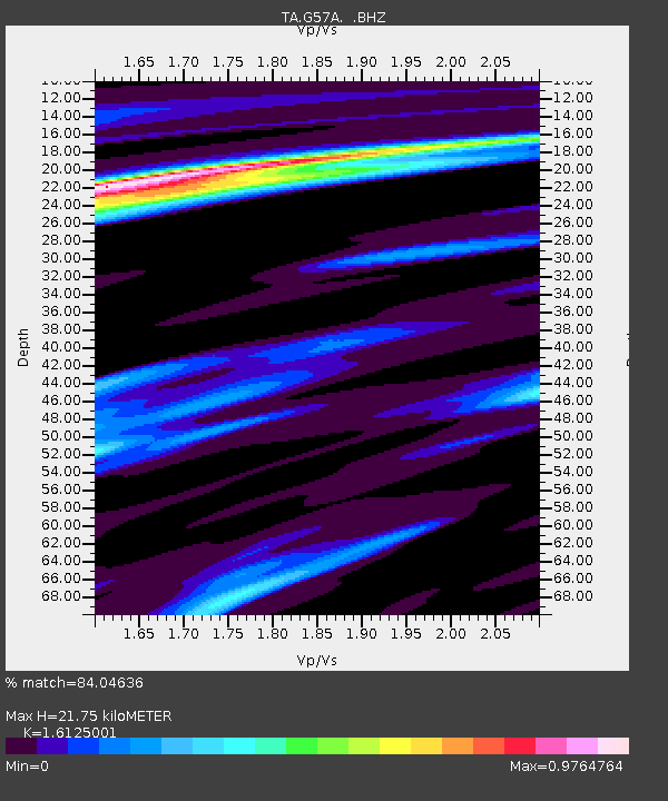
| Estimated Moho Depth: |
21.75 km |
| Estimated Crust Vp/Vs: |
1.61 |
| Assumed Crust Vp: |
6.419 km/s |
| Estimated Crust Vs: |
3.981 km/s |
| Estimated Crust Poisson's Ratio: |
0.19 |
|
| Radial Match: |
84.04636 % |
| Radial Bump: |
302 |
| Transverse Match: |
73.00911 % |
| Transverse Bump: |
375 |
| SOD ConfigId: |
626651 |
| Insert Time: |
2014-04-18 14:02:36.546 +0000 |
| GWidth: |
2.5 |
| Max Bumps: |
400 |
| Tol: |
0.001 |
|

Signal To Noise
| Channel | StoN | STA | LTA |
| TA:G57A: :BHZ:20130905T12:35:41.650007Z | 5.437569 | 1.1176511E-6 | 2.055424E-7 |
| TA:G57A: :BHN:20130905T12:35:41.650007Z | 4.1212955 | 7.775523E-7 | 1.8866696E-7 |
| TA:G57A: :BHE:20130905T12:35:41.650007Z | 1.8216581 | 2.4876468E-7 | 1.3655948E-7 |
| Arrivals |
| Ps | 2.3 SECOND |
| PpPs | 8.1 SECOND |
| PsPs/PpSs | 10 SECOND |


