You are here: Home > Network List > TA - USArray Transportable Network (new EarthScope stations) Stations List
> Station H47A Mio, MI, USA > Earthquake Result Viewer
H47A Mio, MI, USA - Earthquake Result Viewer
| Earthquake location: |
Off Coast Of Costa Rica |
| Earthquake latitude/longitude: |
10.6/-86.1 |
| Earthquake time(UTC): |
2013/09/05 (248) 12:29:15 GMT |
| Earthquake Depth: |
19 km |
| Earthquake Magnitude: |
5.9 MWW, 5.7 MWB, 5.9 MWW, 5.9 MWC |
| Earthquake Catalog/Contributor: |
NEIC PDE/NEIC COMCAT |
|
| Network: |
TA USArray Transportable Network (new EarthScope stations) |
| Station: |
H47A Mio, MI, USA |
| Lat/Lon: |
44.60 N/84.21 W |
| Elevation: |
356 m |
|
| Distance: |
33.9 deg |
| Az: |
2.425 deg |
| Baz: |
183.338 deg |
| Ray Param: |
0.077968016 |
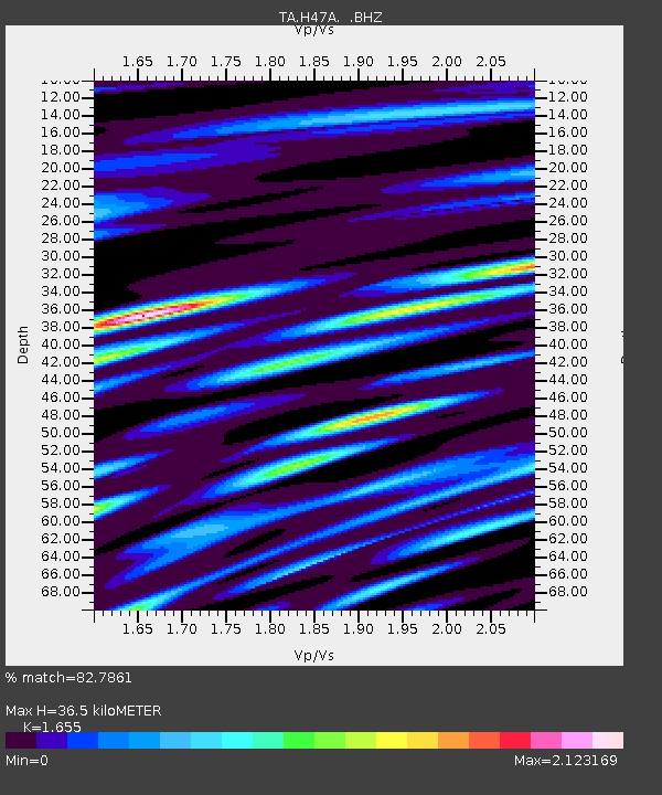
| Estimated Moho Depth: |
36.5 km |
| Estimated Crust Vp/Vs: |
1.65 |
| Assumed Crust Vp: |
6.483 km/s |
| Estimated Crust Vs: |
3.917 km/s |
| Estimated Crust Poisson's Ratio: |
0.21 |
|
| Radial Match: |
82.7861 % |
| Radial Bump: |
400 |
| Transverse Match: |
58.682617 % |
| Transverse Bump: |
400 |
| SOD ConfigId: |
626651 |
| Insert Time: |
2014-04-18 14:02:52.252 +0000 |
| GWidth: |
2.5 |
| Max Bumps: |
400 |
| Tol: |
0.001 |
|

Signal To Noise
| Channel | StoN | STA | LTA |
| TA:H47A: :BHZ:20130905T12:35:26.400007Z | 5.7462144 | 1.2905754E-6 | 2.2459577E-7 |
| TA:H47A: :BHN:20130905T12:35:26.400007Z | 2.770093 | 9.733242E-7 | 3.5136875E-7 |
| TA:H47A: :BHE:20130905T12:35:26.400007Z | 1.0341227 | 4.4333171E-7 | 4.2870317E-7 |
| Arrivals |
| Ps | 4.0 SECOND |
| PpPs | 14 SECOND |
| PsPs/PpSs | 18 SECOND |


