You are here: Home > Network List > TA - USArray Transportable Network (new EarthScope stations) Stations List
> Station I55A Frankford, ON, CAN > Earthquake Result Viewer
I55A Frankford, ON, CAN - Earthquake Result Viewer
| Earthquake location: |
Off Coast Of Costa Rica |
| Earthquake latitude/longitude: |
10.6/-86.1 |
| Earthquake time(UTC): |
2013/09/05 (248) 12:29:15 GMT |
| Earthquake Depth: |
19 km |
| Earthquake Magnitude: |
5.9 MWW, 5.7 MWB, 5.9 MWW, 5.9 MWC |
| Earthquake Catalog/Contributor: |
NEIC PDE/NEIC COMCAT |
|
| Network: |
TA USArray Transportable Network (new EarthScope stations) |
| Station: |
I55A Frankford, ON, CAN |
| Lat/Lon: |
44.22 N/77.68 W |
| Elevation: |
132 m |
|
| Distance: |
34.3 deg |
| Az: |
10.772 deg |
| Baz: |
194.807 deg |
| Ray Param: |
0.07780227 |
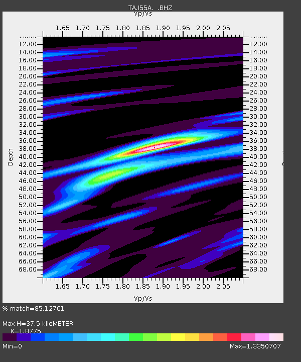
| Estimated Moho Depth: |
37.5 km |
| Estimated Crust Vp/Vs: |
1.88 |
| Assumed Crust Vp: |
6.577 km/s |
| Estimated Crust Vs: |
3.503 km/s |
| Estimated Crust Poisson's Ratio: |
0.30 |
|
| Radial Match: |
85.12701 % |
| Radial Bump: |
325 |
| Transverse Match: |
48.96901 % |
| Transverse Bump: |
346 |
| SOD ConfigId: |
626651 |
| Insert Time: |
2014-04-18 14:03:47.861 +0000 |
| GWidth: |
2.5 |
| Max Bumps: |
400 |
| Tol: |
0.001 |
|
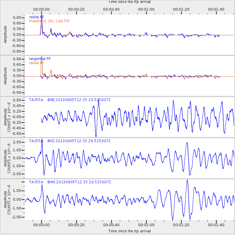
Signal To Noise
| Channel | StoN | STA | LTA |
| TA:I55A: :BHZ:20130905T12:35:29.525007Z | 3.7965777 | 1.0834115E-6 | 2.8536527E-7 |
| TA:I55A: :BHN:20130905T12:35:29.525007Z | 3.2777553 | 8.0344086E-7 | 2.4511922E-7 |
| TA:I55A: :BHE:20130905T12:35:29.525007Z | 3.4066513 | 3.8547822E-7 | 1.1315459E-7 |
| Arrivals |
| Ps | 5.4 SECOND |
| PpPs | 15 SECOND |
| PsPs/PpSs | 21 SECOND |


