You are here: Home > Network List > TA - USArray Transportable Network (new EarthScope stations) Stations List
> Station L46A Eue Claire, MI, USA > Earthquake Result Viewer
L46A Eue Claire, MI, USA - Earthquake Result Viewer
| Earthquake location: |
Off Coast Of Costa Rica |
| Earthquake latitude/longitude: |
10.6/-86.1 |
| Earthquake time(UTC): |
2013/09/05 (248) 12:29:15 GMT |
| Earthquake Depth: |
19 km |
| Earthquake Magnitude: |
5.9 MWW, 5.7 MWB, 5.9 MWW, 5.9 MWC |
| Earthquake Catalog/Contributor: |
NEIC PDE/NEIC COMCAT |
|
| Network: |
TA USArray Transportable Network (new EarthScope stations) |
| Station: |
L46A Eue Claire, MI, USA |
| Lat/Lon: |
42.01 N/86.30 W |
| Elevation: |
223 m |
|
| Distance: |
31.3 deg |
| Az: |
359.719 deg |
| Baz: |
179.629 deg |
| Ray Param: |
0.07909656 |
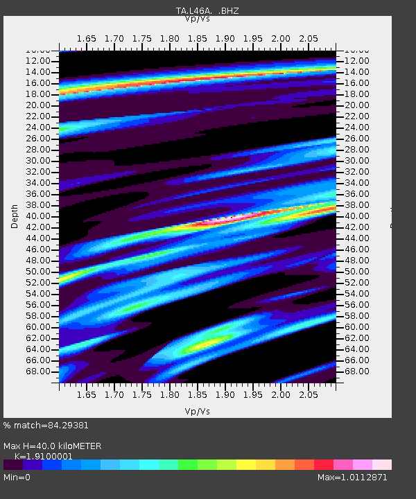
| Estimated Moho Depth: |
40.0 km |
| Estimated Crust Vp/Vs: |
1.91 |
| Assumed Crust Vp: |
6.483 km/s |
| Estimated Crust Vs: |
3.394 km/s |
| Estimated Crust Poisson's Ratio: |
0.31 |
|
| Radial Match: |
84.29381 % |
| Radial Bump: |
400 |
| Transverse Match: |
57.6673 % |
| Transverse Bump: |
400 |
| SOD ConfigId: |
626651 |
| Insert Time: |
2014-04-18 14:05:23.227 +0000 |
| GWidth: |
2.5 |
| Max Bumps: |
400 |
| Tol: |
0.001 |
|
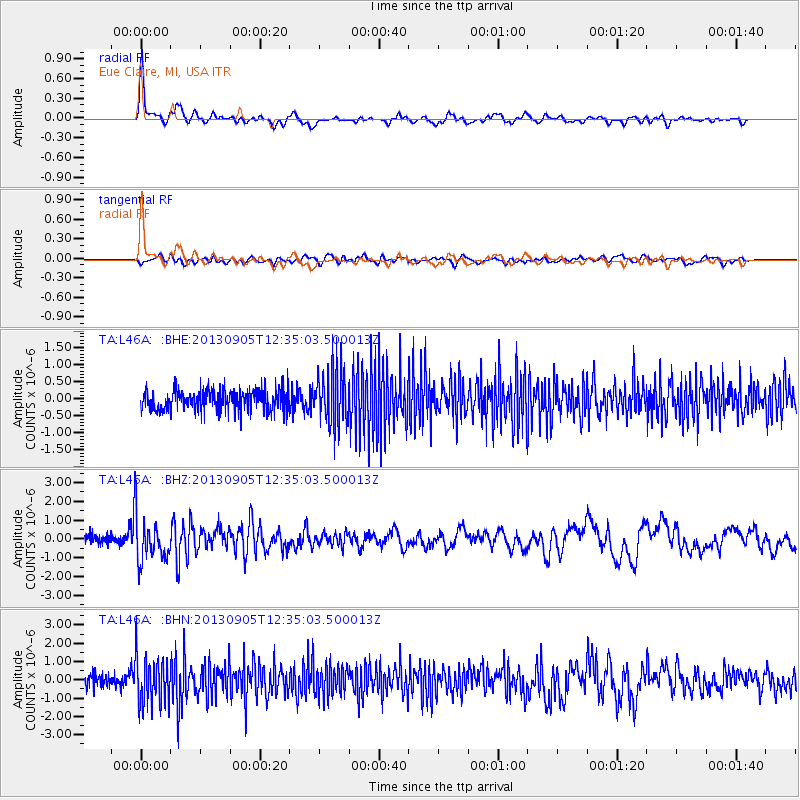
Signal To Noise
| Channel | StoN | STA | LTA |
| TA:L46A: :BHZ:20130905T12:35:03.500013Z | 5.902211 | 1.1820599E-6 | 2.0027409E-7 |
| TA:L46A: :BHN:20130905T12:35:03.500013Z | 4.502193 | 1.3133231E-6 | 2.917074E-7 |
| TA:L46A: :BHE:20130905T12:35:03.500013Z | 2.6435893 | 8.0032993E-7 | 3.0274367E-7 |
| Arrivals |
| Ps | 6.1 SECOND |
| PpPs | 17 SECOND |
| PsPs/PpSs | 23 SECOND |


