You are here: Home > Network List > TA - USArray Transportable Network (new EarthScope stations) Stations List
> Station N51A Ashland, OH, USA > Earthquake Result Viewer
N51A Ashland, OH, USA - Earthquake Result Viewer
| Earthquake location: |
Off Coast Of Costa Rica |
| Earthquake latitude/longitude: |
10.6/-86.1 |
| Earthquake time(UTC): |
2013/09/05 (248) 12:29:15 GMT |
| Earthquake Depth: |
19 km |
| Earthquake Magnitude: |
5.9 MWW, 5.7 MWB, 5.9 MWW, 5.9 MWC |
| Earthquake Catalog/Contributor: |
NEIC PDE/NEIC COMCAT |
|
| Network: |
TA USArray Transportable Network (new EarthScope stations) |
| Station: |
N51A Ashland, OH, USA |
| Lat/Lon: |
40.92 N/82.37 W |
| Elevation: |
343 m |
|
| Distance: |
30.4 deg |
| Az: |
5.587 deg |
| Baz: |
187.256 deg |
| Ray Param: |
0.07933694 |
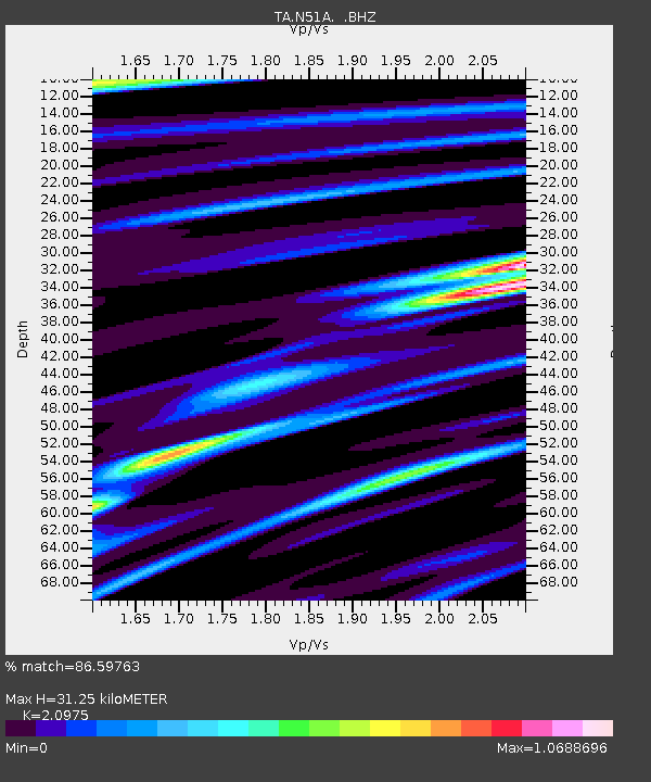
| Estimated Moho Depth: |
31.25 km |
| Estimated Crust Vp/Vs: |
2.10 |
| Assumed Crust Vp: |
6.498 km/s |
| Estimated Crust Vs: |
3.098 km/s |
| Estimated Crust Poisson's Ratio: |
0.35 |
|
| Radial Match: |
86.59763 % |
| Radial Bump: |
372 |
| Transverse Match: |
55.07063 % |
| Transverse Bump: |
400 |
| SOD ConfigId: |
626651 |
| Insert Time: |
2014-04-18 14:06:58.427 +0000 |
| GWidth: |
2.5 |
| Max Bumps: |
400 |
| Tol: |
0.001 |
|

Signal To Noise
| Channel | StoN | STA | LTA |
| TA:N51A: :BHZ:20130905T12:34:55.449995Z | 6.6271734 | 1.1338119E-6 | 1.7108529E-7 |
| TA:N51A: :BHN:20130905T12:34:55.449995Z | 4.2826934 | 7.9671247E-7 | 1.8603072E-7 |
| TA:N51A: :BHE:20130905T12:34:55.449995Z | 1.371126 | 2.7593964E-7 | 2.0125037E-7 |
| Arrivals |
| Ps | 5.7 SECOND |
| PpPs | 14 SECOND |
| PsPs/PpSs | 20 SECOND |


