You are here: Home > Network List > TA - USArray Transportable Network (new EarthScope stations) Stations List
> Station N52A McGinn's Farm, Dalton, OH, USA > Earthquake Result Viewer
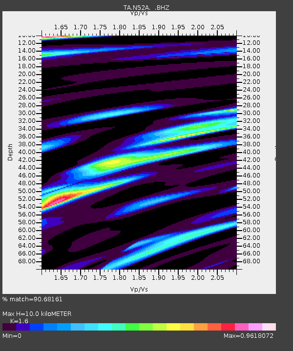
N52A McGinn's Farm, Dalton, OH, USA - Earthquake Result Viewer
| Earthquake location: |
Off Coast Of Costa Rica |
| Earthquake latitude/longitude: |
10.6/-86.1 |
| Earthquake time(UTC): |
2013/09/05 (248) 12:29:15 GMT |
| Earthquake Depth: |
19 km |
| Earthquake Magnitude: |
5.9 MWW, 5.7 MWB, 5.9 MWW, 5.9 MWC |
| Earthquake Catalog/Contributor: |
NEIC PDE/NEIC COMCAT |
|
| Network: |
TA USArray Transportable Network (new EarthScope stations) |
| Station: |
N52A McGinn's Farm, Dalton, OH, USA |
| Lat/Lon: |
40.81 N/81.69 W |
| Elevation: |
331 m |
|
| Distance: |
30.3 deg |
| Az: |
6.64 deg |
| Baz: |
188.614 deg |
| Ray Param: |
0.07934549 |
| Estimated Moho Depth: |
10.0 km |
| Estimated Crust Vp/Vs: |
1.60 |
| Assumed Crust Vp: |
6.483 km/s |
| Estimated Crust Vs: |
4.052 km/s |
| Estimated Crust Poisson's Ratio: |
0.18 |
|
| Radial Match: |
90.68161 % |
| Radial Bump: |
390 |
| Transverse Match: |
61.848877 % |
| Transverse Bump: |
400 |
| SOD ConfigId: |
626651 |
| Insert Time: |
2014-04-18 14:07:00.778 +0000 |
| GWidth: |
2.5 |
| Max Bumps: |
400 |
| Tol: |
0.001 |
|

Signal To Noise
| Channel | StoN | STA | LTA |
| TA:N52A: :BHZ:20130905T12:34:55.150007Z | 7.9654365 | 1.6869237E-6 | 2.1178046E-7 |
| TA:N52A: :BHN:20130905T12:34:55.150007Z | 3.811235 | 9.673375E-7 | 2.5381212E-7 |
| TA:N52A: :BHE:20130905T12:34:55.150007Z | 1.300025 | 3.3275427E-7 | 2.5595992E-7 |
| Arrivals |
| Ps | 1.0 SECOND |
| PpPs | 3.7 SECOND |
| PsPs/PpSs | 4.7 SECOND |


