You are here: Home > Network List > TA - USArray Transportable Network (new EarthScope stations) Stations List
> Station N56A West Decatur, PA, USA > Earthquake Result Viewer
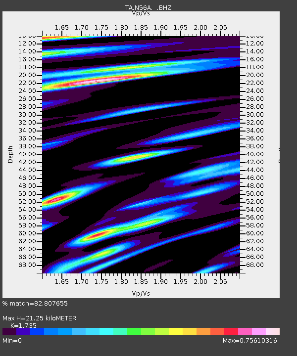
N56A West Decatur, PA, USA - Earthquake Result Viewer
| Earthquake location: |
Off Coast Of Costa Rica |
| Earthquake latitude/longitude: |
10.6/-86.1 |
| Earthquake time(UTC): |
2013/09/05 (248) 12:29:15 GMT |
| Earthquake Depth: |
19 km |
| Earthquake Magnitude: |
5.9 MWW, 5.7 MWB, 5.9 MWW, 5.9 MWC |
| Earthquake Catalog/Contributor: |
NEIC PDE/NEIC COMCAT |
|
| Network: |
TA USArray Transportable Network (new EarthScope stations) |
| Station: |
N56A West Decatur, PA, USA |
| Lat/Lon: |
40.92 N/78.30 W |
| Elevation: |
561 m |
|
| Distance: |
31.0 deg |
| Az: |
11.534 deg |
| Baz: |
195.035 deg |
| Ray Param: |
0.0791801 |
| Estimated Moho Depth: |
21.25 km |
| Estimated Crust Vp/Vs: |
1.74 |
| Assumed Crust Vp: |
6.121 km/s |
| Estimated Crust Vs: |
3.528 km/s |
| Estimated Crust Poisson's Ratio: |
0.25 |
|
| Radial Match: |
82.807655 % |
| Radial Bump: |
400 |
| Transverse Match: |
72.96899 % |
| Transverse Bump: |
400 |
| SOD ConfigId: |
626651 |
| Insert Time: |
2014-04-18 14:07:09.703 +0000 |
| GWidth: |
2.5 |
| Max Bumps: |
400 |
| Tol: |
0.001 |
|

Signal To Noise
| Channel | StoN | STA | LTA |
| TA:N56A: :BHZ:20130905T12:35:00.699995Z | 6.745616 | 1.8050107E-6 | 2.6758278E-7 |
| TA:N56A: :BHN:20130905T12:35:00.699995Z | 3.9178889 | 7.601953E-7 | 1.9403187E-7 |
| TA:N56A: :BHE:20130905T12:35:00.699995Z | 2.0213084 | 3.1498277E-7 | 1.5583113E-7 |
| Arrivals |
| Ps | 2.7 SECOND |
| PpPs | 8.8 SECOND |
| PsPs/PpSs | 12 SECOND |


