You are here: Home > Network List > TA - USArray Transportable Network (new EarthScope stations) Stations List
> Station N60A Cedar Hill Farm, Mount Bethel, PA, USA > Earthquake Result Viewer
N60A Cedar Hill Farm, Mount Bethel, PA, USA - Earthquake Result Viewer
| Earthquake location: |
Off Coast Of Costa Rica |
| Earthquake latitude/longitude: |
10.6/-86.1 |
| Earthquake time(UTC): |
2013/09/05 (248) 12:29:15 GMT |
| Earthquake Depth: |
19 km |
| Earthquake Magnitude: |
5.9 MWW, 5.7 MWB, 5.9 MWW, 5.9 MWC |
| Earthquake Catalog/Contributor: |
NEIC PDE/NEIC COMCAT |
|
| Network: |
TA USArray Transportable Network (new EarthScope stations) |
| Station: |
N60A Cedar Hill Farm, Mount Bethel, PA, USA |
| Lat/Lon: |
40.87 N/75.10 W |
| Elevation: |
189 m |
|
| Distance: |
31.7 deg |
| Az: |
15.994 deg |
| Baz: |
200.929 deg |
| Ray Param: |
0.078956984 |
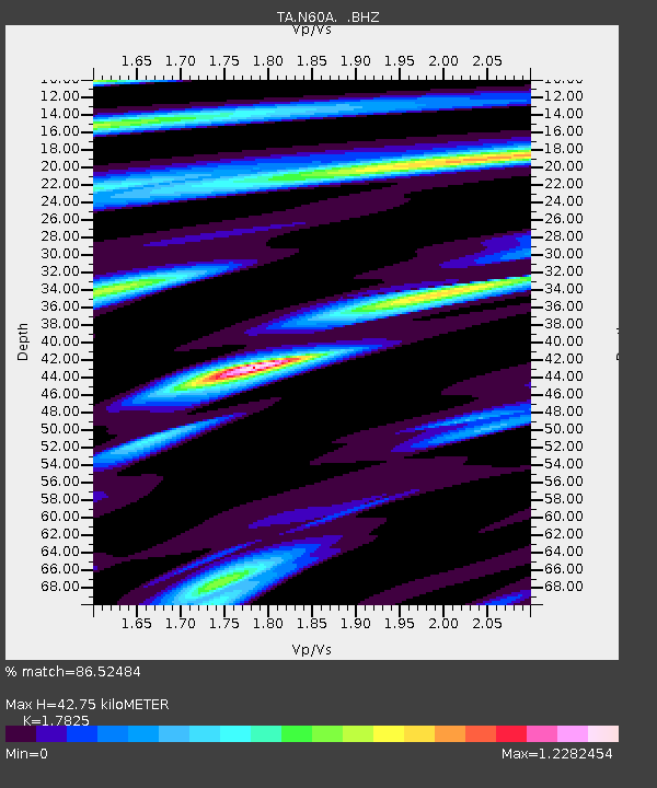
| Estimated Moho Depth: |
42.75 km |
| Estimated Crust Vp/Vs: |
1.78 |
| Assumed Crust Vp: |
6.283 km/s |
| Estimated Crust Vs: |
3.525 km/s |
| Estimated Crust Poisson's Ratio: |
0.27 |
|
| Radial Match: |
86.52484 % |
| Radial Bump: |
325 |
| Transverse Match: |
68.016624 % |
| Transverse Bump: |
400 |
| SOD ConfigId: |
626651 |
| Insert Time: |
2014-04-18 14:07:18.920 +0000 |
| GWidth: |
2.5 |
| Max Bumps: |
400 |
| Tol: |
0.001 |
|

Signal To Noise
| Channel | StoN | STA | LTA |
| TA:N60A: :BHZ:20130905T12:35:06.899Z | 4.6885395 | 1.013347E-6 | 2.1613273E-7 |
| TA:N60A: :BHN:20130905T12:35:06.899Z | 3.344924 | 5.9061176E-7 | 1.7656956E-7 |
| TA:N60A: :BHE:20130905T12:35:06.899Z | 2.8080025 | 2.9534783E-7 | 1.0518075E-7 |
| Arrivals |
| Ps | 5.7 SECOND |
| PpPs | 18 SECOND |
| PsPs/PpSs | 23 SECOND |


