You are here: Home > Network List > TA - USArray Transportable Network (new EarthScope stations) Stations List
> Station SUSD Miller, SD, USA > Earthquake Result Viewer
SUSD Miller, SD, USA - Earthquake Result Viewer
| Earthquake location: |
Off Coast Of Costa Rica |
| Earthquake latitude/longitude: |
10.6/-86.1 |
| Earthquake time(UTC): |
2013/09/05 (248) 12:29:15 GMT |
| Earthquake Depth: |
19 km |
| Earthquake Magnitude: |
5.9 MWW, 5.7 MWB, 5.9 MWW, 5.9 MWC |
| Earthquake Catalog/Contributor: |
NEIC PDE/NEIC COMCAT |
|
| Network: |
TA USArray Transportable Network (new EarthScope stations) |
| Station: |
SUSD Miller, SD, USA |
| Lat/Lon: |
44.44 N/98.96 W |
| Elevation: |
520 m |
|
| Distance: |
35.5 deg |
| Az: |
344.071 deg |
| Baz: |
157.871 deg |
| Ray Param: |
0.07716716 |
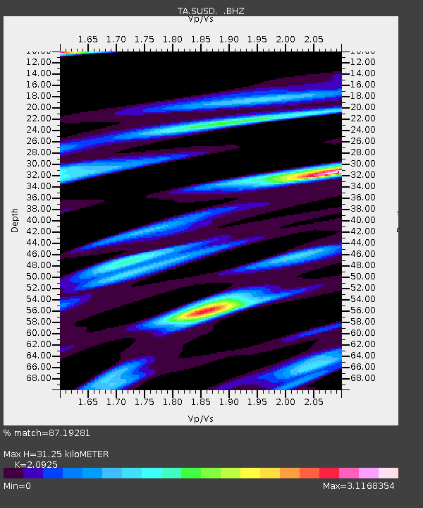
| Estimated Moho Depth: |
31.25 km |
| Estimated Crust Vp/Vs: |
2.09 |
| Assumed Crust Vp: |
6.53 km/s |
| Estimated Crust Vs: |
3.121 km/s |
| Estimated Crust Poisson's Ratio: |
0.35 |
|
| Radial Match: |
87.19281 % |
| Radial Bump: |
339 |
| Transverse Match: |
67.67493 % |
| Transverse Bump: |
400 |
| SOD ConfigId: |
626651 |
| Insert Time: |
2014-04-18 14:08:04.082 +0000 |
| GWidth: |
2.5 |
| Max Bumps: |
400 |
| Tol: |
0.001 |
|

Signal To Noise
| Channel | StoN | STA | LTA |
| TA:SUSD: :BHZ:20130905T12:35:40.074995Z | 6.931055 | 1.1004668E-6 | 1.5877335E-7 |
| TA:SUSD: :BHN:20130905T12:35:40.074995Z | 5.979207 | 1.5230029E-6 | 2.5471653E-7 |
| TA:SUSD: :BHE:20130905T12:35:40.074995Z | 3.072558 | 8.083782E-7 | 2.6309618E-7 |
| Arrivals |
| Ps | 5.6 SECOND |
| PpPs | 14 SECOND |
| PsPs/PpSs | 19 SECOND |


