You are here: Home > Network List > US - United States National Seismic Network Stations List
> Station ERPA Erie, Pennsylvania, USA > Earthquake Result Viewer
ERPA Erie, Pennsylvania, USA - Earthquake Result Viewer
| Earthquake location: |
Off Coast Of Costa Rica |
| Earthquake latitude/longitude: |
10.6/-86.1 |
| Earthquake time(UTC): |
2013/09/05 (248) 12:29:15 GMT |
| Earthquake Depth: |
19 km |
| Earthquake Magnitude: |
5.9 MWW, 5.7 MWB, 5.9 MWW, 5.9 MWC |
| Earthquake Catalog/Contributor: |
NEIC PDE/NEIC COMCAT |
|
| Network: |
US United States National Seismic Network |
| Station: |
ERPA Erie, Pennsylvania, USA |
| Lat/Lon: |
42.12 N/79.99 W |
| Elevation: |
306 m |
|
| Distance: |
31.9 deg |
| Az: |
8.631 deg |
| Baz: |
191.439 deg |
| Ray Param: |
0.07888364 |
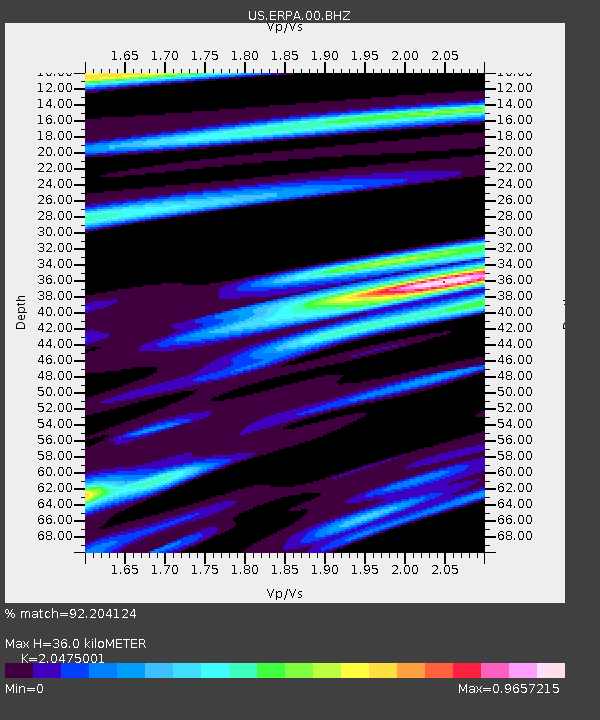
| Estimated Moho Depth: |
36.0 km |
| Estimated Crust Vp/Vs: |
2.05 |
| Assumed Crust Vp: |
6.419 km/s |
| Estimated Crust Vs: |
3.135 km/s |
| Estimated Crust Poisson's Ratio: |
0.34 |
|
| Radial Match: |
92.204124 % |
| Radial Bump: |
349 |
| Transverse Match: |
60.41687 % |
| Transverse Bump: |
400 |
| SOD ConfigId: |
626651 |
| Insert Time: |
2014-04-18 14:08:55.699 +0000 |
| GWidth: |
2.5 |
| Max Bumps: |
400 |
| Tol: |
0.001 |
|
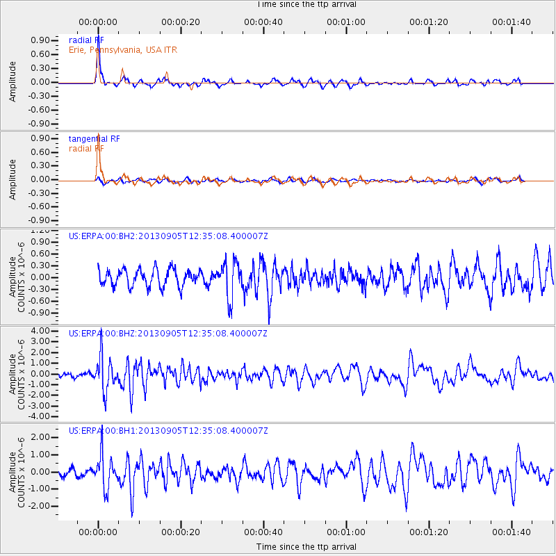
Signal To Noise
| Channel | StoN | STA | LTA |
| US:ERPA:00:BHZ:20130905T12:35:08.400007Z | 9.277385 | 1.6285337E-6 | 1.75538E-7 |
| US:ERPA:00:BH1:20130905T12:35:08.400007Z | 6.3036156 | 9.82275E-7 | 1.5582724E-7 |
| US:ERPA:00:BH2:20130905T12:35:08.400007Z | 2.220287 | 4.6990834E-7 | 2.1164306E-7 |
| Arrivals |
| Ps | 6.3 SECOND |
| PpPs | 16 SECOND |
| PsPs/PpSs | 22 SECOND |


