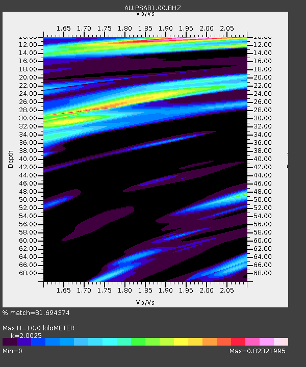
PSAB1 Pilbara Seismic Array Element B1 - Earthquake Result Viewer

Earthquake location: Philippine Islands Region
Earthquake latitude/longitude: 20.2/122.3
Earthquake time(UTC): 2013/09/06 (249) 11:33:53 GMT
Earthquake Depth: 175 km
Earthquake Magnitude: 5.9 MWW, 5.9 MWW, 6.0 MWC, 6.0 MWB
Earthquake Catalog/Contributor: NEIC PDE/NEIC COMCAT
Network: AU Australian Seismological Centre
Station: PSAB1 Pilbara Seismic Array Element B1
Lat/Lon: 21.57 S/119.82 E
Elevation: 317 m
Distance: 41.6 deg
Az: 183.505 deg
Baz: 3.538 deg
Ray Param: 0.073061034
Estimated Moho Depth: 10.0 km
Estimated Crust Vp/Vs: 2.00
Assumed Crust Vp: 6.464 km/s
Estimated Crust Vs: 3.228 km/s
Estimated Crust Poisson's Ratio: 0.33
Radial Match: 81.694374 %
Radial Bump: 400
Transverse Match: 75.73985 %
Transverse Bump: 400
SOD ConfigId: 626651
Insert Time: 2014-04-18 14:31:53.724 +0000
GWidth: 2.5
Max Bumps: 400
Tol: 0.001

Signal To Noise

ChannelStoNSTALTA
AU:PSAB1:00:BHZ:20130906T11:40:53.393993Z1.1789331.265678E-61.0735791E-6
AU:PSAB1:00:BH1:20130906T11:40:53.393993Z1.81461255.8880363E-73.2447898E-7
AU:PSAB1:00:BH2:20130906T11:40:53.393993Z2.23296079.273949E-74.1532078E-7
Arrivals
Ps1.6 SECOND
PpPs4.4 SECOND
PsPs/PpSs6.0 SECOND