You are here: Home > Network List > II - Global Seismograph Network (GSN - IRIS/IDA) Stations List
> Station WRAB Tennant Creek, NT, Australia > Earthquake Result Viewer
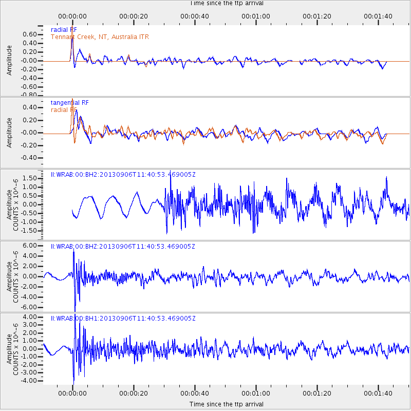
WRAB Tennant Creek, NT, Australia - Earthquake Result Viewer
*The percent match for this event was below the threshold and hence no stack was calculated.
| Earthquake location: |
Philippine Islands Region |
| Earthquake latitude/longitude: |
20.2/122.3 |
| Earthquake time(UTC): |
2013/09/06 (249) 11:33:53 GMT |
| Earthquake Depth: |
175 km |
| Earthquake Magnitude: |
5.9 MWW, 5.9 MWW, 6.0 MWC, 6.0 MWB |
| Earthquake Catalog/Contributor: |
NEIC PDE/NEIC COMCAT |
|
| Network: |
II Global Seismograph Network (GSN - IRIS/IDA) |
| Station: |
WRAB Tennant Creek, NT, Australia |
| Lat/Lon: |
19.93 S/134.36 E |
| Elevation: |
366 m |
|
| Distance: |
41.6 deg |
| Az: |
162.794 deg |
| Baz: |
342.821 deg |
| Ray Param: |
$rayparam |
*The percent match for this event was below the threshold and hence was not used in the summary stack. |
|
| Radial Match: |
65.77933 % |
| Radial Bump: |
400 |
| Transverse Match: |
77.29935 % |
| Transverse Bump: |
400 |
| SOD ConfigId: |
626651 |
| Insert Time: |
2014-04-18 14:37:39.230 +0000 |
| GWidth: |
2.5 |
| Max Bumps: |
400 |
| Tol: |
0.001 |
|
Signal To Noise
| Channel | StoN | STA | LTA |
| II:WRAB:00:BHZ:20130906T11:40:53.469005Z | 3.76188 | 2.3958291E-6 | 6.368702E-7 |
| II:WRAB:00:BH1:20130906T11:40:53.469005Z | 3.9001997 | 1.7861315E-6 | 4.57959E-7 |
| II:WRAB:00:BH2:20130906T11:40:53.469005Z | 1.5183519 | 6.582165E-7 | 4.335072E-7 |
| Arrivals |
| Ps | |
| PpPs | |
| PsPs/PpSs | |


