You are here: Home > Network List > NI - North-East Italy Broadband Network Stations List
> Station CGRP Cima Grappa > Earthquake Result Viewer
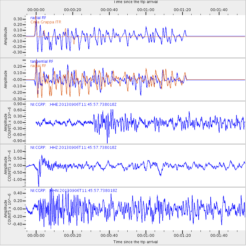
CGRP Cima Grappa - Earthquake Result Viewer
*The percent match for this event was below the threshold and hence no stack was calculated.
| Earthquake location: |
Philippine Islands Region |
| Earthquake latitude/longitude: |
20.2/122.3 |
| Earthquake time(UTC): |
2013/09/06 (249) 11:33:53 GMT |
| Earthquake Depth: |
175 km |
| Earthquake Magnitude: |
5.9 MWW, 5.9 MWW, 6.0 MWC, 6.0 MWB |
| Earthquake Catalog/Contributor: |
NEIC PDE/NEIC COMCAT |
|
| Network: |
NI North-East Italy Broadband Network |
| Station: |
CGRP Cima Grappa |
| Lat/Lon: |
45.88 N/11.80 E |
| Elevation: |
1757 m |
|
| Distance: |
89.1 deg |
| Az: |
319.131 deg |
| Baz: |
61.635 deg |
| Ray Param: |
$rayparam |
*The percent match for this event was below the threshold and hence was not used in the summary stack. |
|
| Radial Match: |
63.814823 % |
| Radial Bump: |
400 |
| Transverse Match: |
50.17578 % |
| Transverse Bump: |
400 |
| SOD ConfigId: |
626651 |
| Insert Time: |
2014-04-18 14:39:38.030 +0000 |
| GWidth: |
2.5 |
| Max Bumps: |
400 |
| Tol: |
0.001 |
|
Signal To Noise
| Channel | StoN | STA | LTA |
| NI:CGRP: :HHZ:20130906T11:45:57.738018Z | 9.277108 | 4.9398005E-7 | 5.3247206E-8 |
| NI:CGRP: :HHN:20130906T11:45:57.738018Z | 2.8626368 | 1.6622565E-7 | 5.806732E-8 |
| NI:CGRP: :HHE:20130906T11:45:57.738018Z | 3.108846 | 2.3698571E-7 | 7.6229476E-8 |
| Arrivals |
| Ps | |
| PpPs | |
| PsPs/PpSs | |


