You are here: Home > Network List > TA - USArray Transportable Network (new EarthScope stations) Stations List
> Station G03D McMinnville, OR, USA > Earthquake Result Viewer
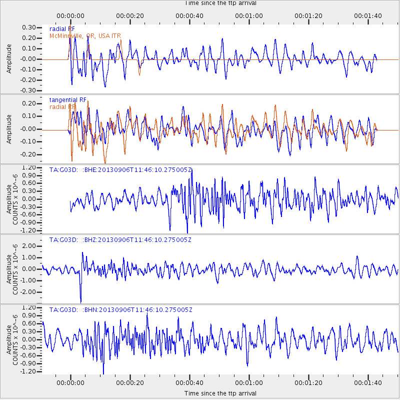
G03D McMinnville, OR, USA - Earthquake Result Viewer
*The percent match for this event was below the threshold and hence no stack was calculated.
| Earthquake location: |
Philippine Islands Region |
| Earthquake latitude/longitude: |
20.2/122.3 |
| Earthquake time(UTC): |
2013/09/06 (249) 11:33:53 GMT |
| Earthquake Depth: |
175 km |
| Earthquake Magnitude: |
5.9 MWW, 5.9 MWW, 6.0 MWC, 6.0 MWB |
| Earthquake Catalog/Contributor: |
NEIC PDE/NEIC COMCAT |
|
| Network: |
TA USArray Transportable Network (new EarthScope stations) |
| Station: |
G03D McMinnville, OR, USA |
| Lat/Lon: |
45.21 N/123.26 W |
| Elevation: |
222 m |
|
| Distance: |
91.8 deg |
| Az: |
40.089 deg |
| Baz: |
301.149 deg |
| Ray Param: |
$rayparam |
*The percent match for this event was below the threshold and hence was not used in the summary stack. |
|
| Radial Match: |
59.96571 % |
| Radial Bump: |
400 |
| Transverse Match: |
64.26917 % |
| Transverse Bump: |
400 |
| SOD ConfigId: |
626651 |
| Insert Time: |
2014-04-18 14:42:08.947 +0000 |
| GWidth: |
2.5 |
| Max Bumps: |
400 |
| Tol: |
0.001 |
|
Signal To Noise
| Channel | StoN | STA | LTA |
| TA:G03D: :BHZ:20130906T11:46:10.275005Z | 3.5562632 | 8.2133243E-7 | 2.3095379E-7 |
| TA:G03D: :BHN:20130906T11:46:10.275005Z | 0.9695768 | 2.5247888E-7 | 2.6040112E-7 |
| TA:G03D: :BHE:20130906T11:46:10.275005Z | 1.923942 | 4.059268E-7 | 2.1098704E-7 |
| Arrivals |
| Ps | |
| PpPs | |
| PsPs/PpSs | |


