You are here: Home > Network List > TA - USArray Transportable Network (new EarthScope stations) Stations List
> Station J01E Myrtle Point, OR, USA > Earthquake Result Viewer
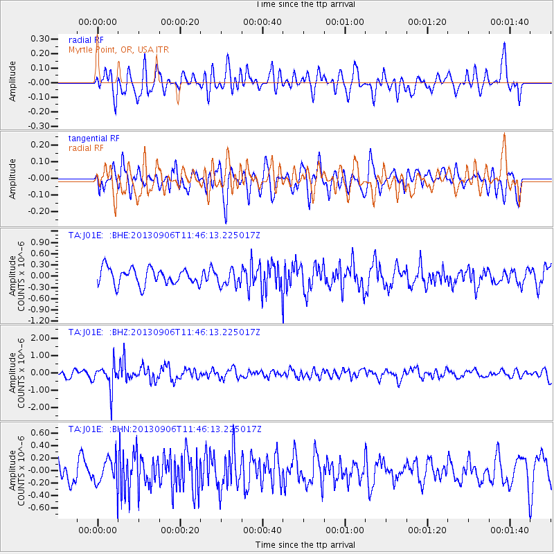
J01E Myrtle Point, OR, USA - Earthquake Result Viewer
*The percent match for this event was below the threshold and hence no stack was calculated.
| Earthquake location: |
Philippine Islands Region |
| Earthquake latitude/longitude: |
20.2/122.3 |
| Earthquake time(UTC): |
2013/09/06 (249) 11:33:53 GMT |
| Earthquake Depth: |
175 km |
| Earthquake Magnitude: |
5.9 MWW, 5.9 MWW, 6.0 MWC, 6.0 MWB |
| Earthquake Catalog/Contributor: |
NEIC PDE/NEIC COMCAT |
|
| Network: |
TA USArray Transportable Network (new EarthScope stations) |
| Station: |
J01E Myrtle Point, OR, USA |
| Lat/Lon: |
43.16 N/123.93 W |
| Elevation: |
128 m |
|
| Distance: |
92.5 deg |
| Az: |
42.096 deg |
| Baz: |
300.61 deg |
| Ray Param: |
$rayparam |
*The percent match for this event was below the threshold and hence was not used in the summary stack. |
|
| Radial Match: |
51.857197 % |
| Radial Bump: |
400 |
| Transverse Match: |
59.808018 % |
| Transverse Bump: |
400 |
| SOD ConfigId: |
626651 |
| Insert Time: |
2014-04-18 14:42:33.109 +0000 |
| GWidth: |
2.5 |
| Max Bumps: |
400 |
| Tol: |
0.001 |
|
Signal To Noise
| Channel | StoN | STA | LTA |
| TA:J01E: :BHZ:20130906T11:46:13.225017Z | 4.5810366 | 7.522673E-7 | 1.6421333E-7 |
| TA:J01E: :BHN:20130906T11:46:13.225017Z | 1.5907172 | 2.289576E-7 | 1.4393358E-7 |
| TA:J01E: :BHE:20130906T11:46:13.225017Z | 0.99540967 | 2.1780716E-7 | 2.1881158E-7 |
| Arrivals |
| Ps | |
| PpPs | |
| PsPs/PpSs | |


