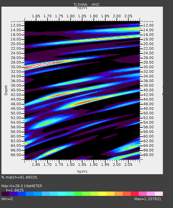
SHAA Shaartuz, Tajikistan - Earthquake Result Viewer

Earthquake location: Philippine Islands Region
Earthquake latitude/longitude: 20.2/122.3
Earthquake time(UTC): 2013/09/06 (249) 11:33:53 GMT
Earthquake Depth: 175 km
Earthquake Magnitude: 5.9 MWW, 5.9 MWW, 6.0 MWC, 6.0 MWB
Earthquake Catalog/Contributor: NEIC PDE/NEIC COMCAT
Network: TJ Tajikistan National Seismic Network
Station: SHAA Shaartuz, Tajikistan
Lat/Lon: 37.56 N/68.12 E
Elevation: 868 m
Distance: 49.8 deg
Az: 302.519 deg
Baz: 94.592 deg
Ray Param: 0.06780402
Estimated Moho Depth: 29.0 km
Estimated Crust Vp/Vs: 1.66
Assumed Crust Vp: 6.213 km/s
Estimated Crust Vs: 3.737 km/s
Estimated Crust Poisson's Ratio: 0.22
Radial Match: 81.69025 %
Radial Bump: 400
Transverse Match: 59.99104 %
Transverse Bump: 400
SOD ConfigId: 626651
Insert Time: 2014-04-18 14:43:15.990 +0000
GWidth: 2.5
Max Bumps: 400
Tol: 0.001

Signal To Noise

ChannelStoNSTALTA
TJ:SHAA: :HHZ:20130906T11:41:58.199993Z6.2175391.1103331E-61.785808E-7
TJ:SHAA: :HHN:20130906T11:41:58.199993Z1.49058871.2944915E-78.684431E-8
TJ:SHAA: :HHE:20130906T11:41:58.199993Z5.1496035.968585E-71.1590379E-7
Arrivals
Ps3.3 SECOND
PpPs12 SECOND
PsPs/PpSs15 SECOND