You are here: Home > Network List > CI - Caltech Regional Seismic Network Stations List
> Station TIN Tinemaha, California, USA > Earthquake Result Viewer
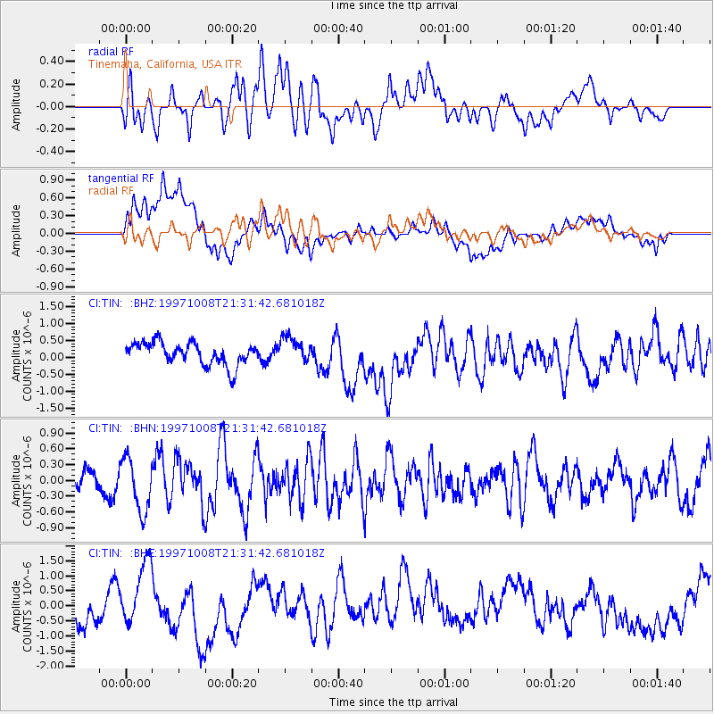
TIN Tinemaha, California, USA - Earthquake Result Viewer
*The percent match for this event was below the threshold and hence no stack was calculated.
| Earthquake location: |
Hokkaido, Japan Region |
| Earthquake latitude/longitude: |
41.9/144.8 |
| Earthquake time(UTC): |
1997/10/08 (281) 21:20:59 GMT |
| Earthquake Depth: |
33 km |
| Earthquake Magnitude: |
5.5 MB, 5.6 MS, 5.9 UNKNOWN, 5.9 MW |
| Earthquake Catalog/Contributor: |
WHDF/NEIC |
|
| Network: |
CI Caltech Regional Seismic Network |
| Station: |
TIN Tinemaha, California, USA |
| Lat/Lon: |
37.05 N/118.23 W |
| Elevation: |
1164 m |
|
| Distance: |
70.9 deg |
| Az: |
57.173 deg |
| Baz: |
308.371 deg |
| Ray Param: |
$rayparam |
*The percent match for this event was below the threshold and hence was not used in the summary stack. |
|
| Radial Match: |
49.034107 % |
| Radial Bump: |
400 |
| Transverse Match: |
42.757538 % |
| Transverse Bump: |
400 |
| SOD ConfigId: |
4480 |
| Insert Time: |
2010-02-25 20:52:06.824 +0000 |
| GWidth: |
2.5 |
| Max Bumps: |
400 |
| Tol: |
0.001 |
|
Signal To Noise
| Channel | StoN | STA | LTA |
| CI:TIN: :BHN:19971008T21:31:42.681018Z | 3.3833668 | 5.117055E-7 | 1.512415E-7 |
| CI:TIN: :BHE:19971008T21:31:42.681018Z | 2.1572084 | 1.0160876E-6 | 4.710197E-7 |
| CI:TIN: :BHZ:19971008T21:31:42.681018Z | 1.146928 | 3.8224556E-7 | 3.3327774E-7 |
| Arrivals |
| Ps | |
| PpPs | |
| PsPs/PpSs | |


