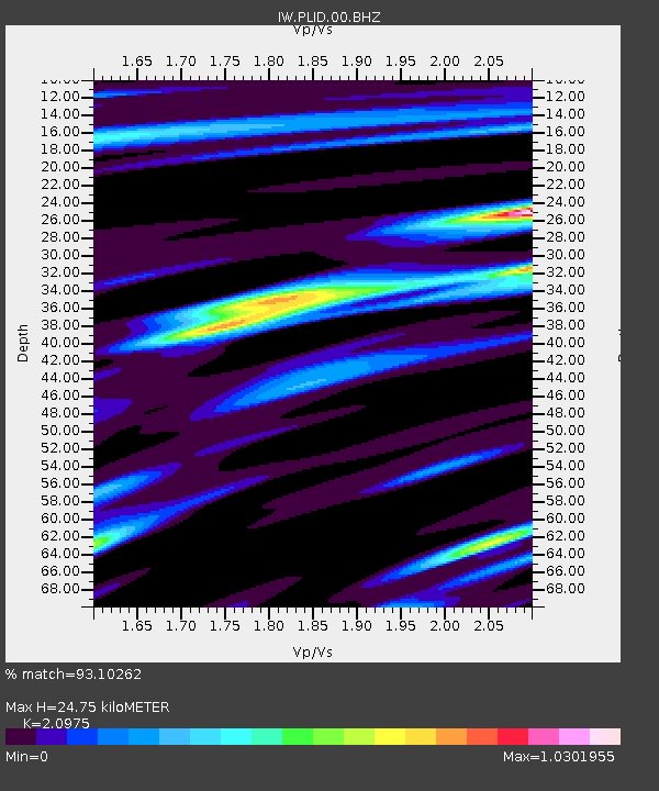
PLID Pearl Lake, Idaho, USA - Earthquake Result Viewer
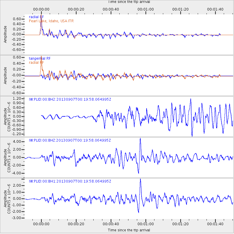
Earthquake location: Near Coast Of Chiapas, Mexico
Earthquake latitude/longitude: 14.6/-92.1
Earthquake time(UTC): 2013/09/07 (250) 00:13:29 GMT
Earthquake Depth: 66 km
Earthquake Magnitude: 6.4 MWW, 6.4 MWB, 6.4 MWC, 6.4 MWW, 6.5 MWC
Earthquake Catalog/Contributor: NEIC PDE/NEIC COMCAT
Network: IW Intermountain West
Station: PLID Pearl Lake, Idaho, USA
Lat/Lon: 45.09 N/116.00 W
Elevation: 2164 m
Distance: 36.5 deg
Az: 331.169 deg
Baz: 138.776 deg
Ray Param: 0.07646429
Estimated Moho Depth: 24.75 km
Estimated Crust Vp/Vs: 2.10
Assumed Crust Vp: 6.571 km/s
Estimated Crust Vs: 3.133 km/s
Estimated Crust Poisson's Ratio: 0.35
Radial Match: 93.10262 %
Radial Bump: 356
Transverse Match: 88.48069 %
Transverse Bump: 400
SOD ConfigId: 626651
Insert Time: 2014-04-18 14:56:51.055 +0000
GWidth: 2.5
Max Bumps: 400
Tol: 0.001

Signal To Noise

ChannelStoNSTALTA
IW:PLID:00:BHZ:20130907T00:19:58.064995Z3.69580394.673689E-71.2645933E-7
IW:PLID:00:BH1:20130907T00:19:58.064995Z3.1357572.1790113E-76.948917E-8
IW:PLID:00:BH2:20130907T00:19:58.064995Z2.658092.0197173E-77.598378E-8
Arrivals
Ps4.4 SECOND
PpPs11 SECOND
PsPs/PpSs15 SECOND