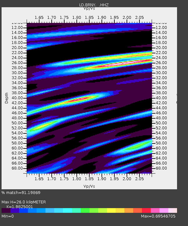
BRNY Black Rock Forest, Cornwall, NY - Earthquake Result Viewer

Earthquake location: Near Coast Of Chiapas, Mexico
Earthquake latitude/longitude: 14.6/-92.1
Earthquake time(UTC): 2013/09/07 (250) 00:13:29 GMT
Earthquake Depth: 66 km
Earthquake Magnitude: 6.4 MWW, 6.4 MWB, 6.4 MWC, 6.4 MWW, 6.5 MWC
Earthquake Catalog/Contributor: NEIC PDE/NEIC COMCAT
Network: LD Lamont-Doherty Cooperative Seismographic Network
Station: BRNY Black Rock Forest, Cornwall, NY
Lat/Lon: 41.41 N/74.01 W
Elevation: 248 m
Distance: 31.0 deg
Az: 27.0 deg
Baz: 215.756 deg
Ray Param: 0.07909045
Estimated Moho Depth: 26.0 km
Estimated Crust Vp/Vs: 1.98
Assumed Crust Vp: 6.283 km/s
Estimated Crust Vs: 3.169 km/s
Estimated Crust Poisson's Ratio: 0.33
Radial Match: 91.19869 %
Radial Bump: 193
Transverse Match: 56.285767 %
Transverse Bump: 400
SOD ConfigId: 626651
Insert Time: 2014-04-18 14:57:16.453 +0000
GWidth: 2.5
Max Bumps: 400
Tol: 0.001

Signal To Noise

ChannelStoNSTALTA
LD:BRNY: :HHZ:20130907T00:19:10.521996Z2.99987847.0861347E-72.3621408E-7
LD:BRNY: :HHN:20130907T00:19:10.521996Z1.96288283.922522E-71.9983476E-7
LD:BRNY: :HHE:20130907T00:19:10.521996Z3.00628924.7254926E-71.5718689E-7
Arrivals
Ps4.4 SECOND
PpPs12 SECOND
PsPs/PpSs16 SECOND